5/6/20

Ediz Hook

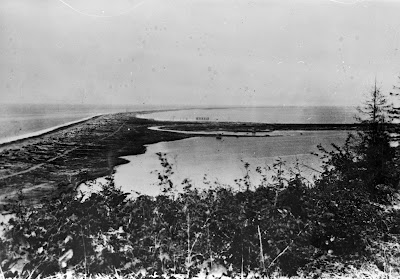
No trip down the memory lane of Washington's shorelines would be complete without a stop in to consider Ediz Hook.  Ediz Hook is a roughly 3.5 mile long "recurved" spit extending into the Central Strait of Juan de Fuca, the embayment of which forms Port Angeles Harbor.  Ediz Hook hosts a pulp and paper mill, a road, a boat ramp, the Puget Sound Pilot's boat station, and a large US Coast Guard facility.  Not surprisingly, Ediz Hook has been heavily modified over time, and looks considerably different today than it did at the turn of the 20th century.  This view of Ediz Hook (taken from somewhere near modern Crown Park), for example, dates to 1884:

1884 view of Ediz Hook.  Photo is part of the Washington Rural Heritage collection, accessed via the North Olympic Library System.
And here is the modern view from the same perspective:

Photo collected by Ian Miller 19 February 2014
Prominent in the modern view is the pulp and paper mill, first built around 1920.  Harder to see from this vantage are the many other modifications that have turned Ediz Hook from the natural sand spit it was in 1884 into something that many take to be a man-made harbor defense works.  Here is the view down on the beach near the mill, for example:

10 February 2017 photo taken looking west from a point just to the east of the mill shown in the photo above.  Photo collected by Ian Miller
showing the large rock, placed to protect Ediz Hook from erosion, that is now a prominent feature of the Ediz Hook shoreline.

5/5/20

Port Williams...Bustling Port Now County Park

Port Williams is located on the Olympic Peninsula near Sequim, between Sequim Bay and New Dungeness Lighthouse. It’s currently a Clallam County park with a boat ramp and wonderful beach combing opportunities. But in the late 1800s and into the early 1900s, this spot served as a port for Mosquito Fleet steamers that were providing supplies and transportation to the new settlers of the Sequim prairie. The wharf was built in 1890 and included a hotel, restaurant, post office, store and dance hall. The Port Williams townsite was abandoned in 1922.

Port Williams - Then (early 1900s) and Now (2020)

The historic image is courtesy of the Museum and Arts Center in Sequim-Dungeness. The exact date is unknown, but the ship, the Alice Gertrude, was built in 1898 and ended its run in Clallam Bay, running aground during a snowstorm in 1907.

It’s interesting to note the dark stripe that runs horizontally, halfway up the bluff in both photos. This is the result of glacio-lacustrine deposits, sediment that settled in glacial meltwater during the Vashon glaciation period. More than 14,000 years ago, the Cordilleran glacial ice sheet, measuring at least 3000 feet deep, covered most of Western Washington. As it advanced and retreated, the glacier carved much of Puget Sound into the landforms and waterways we see today. It also left us with timeless features to match up in then and now photographs of our ever-eroding bluffs.
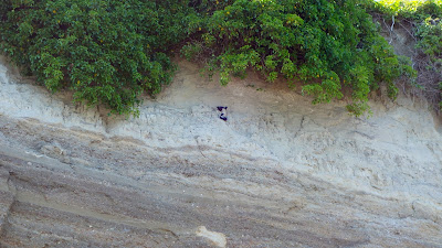
Port Williams bluff with two layers of sediment and 2 pigeon guillemots
A better look at the different sediment layers in the bluff, with bonus pigeon guillemots!

There are many other historic photographs of Port Williams to enjoy in the Bert Kellogg Collection, available for viewing on the Washington Rural Heritage digital archive website or in person at the Port Angeles branch of the North Olympic Library System.
4/29/20

The Red Lion Hotel on the Port Angeles Waterfront

Like many of the cities on the shoreline of the Salish Sea, downtown Port Angeles is built mostly on fill, and this fill material underlies one of the most most prominent buildings on the waterfront...the Red Lion Hotel.

Top photo:  Early 1900's photo from the Bert Kellogg collection, courtesy of the North Olympic Library System. Bottom photo: 2014 photo of the Red Lion Hotel on the Port Angeles waterfront. 
The historic photo above provides a sense for how dramatically that fill changed the coastal landscape, and how much the uses of the shoreline have changed.

Of special note in the historic perspective above is the wood cribbing used to buttress Front Street, still the main route into downtown from the east, and the small buildings on the beach.

4/28/20

Looking up Salmon Bay to the Train Bridge and Locks - Now and Then

Here's another now and then view shot from about a block south of Salmon Bay Charlie's place, off 39th Ave W in Magnolia. 

The 1908 view shows why the name Shilshole means "threading the bread" in regards to getting a canoe or later a boat up past the mid-channel sand bars to upper Salmon Bay. 

Top Photo by: Wilse, Neg# 1165

The big sandbar on the Ballard side was titled CHutqeedud meaning "lying curled up" or "lying curled up like a pillow." It was known for great clamming.

As a paddler who loves to play in tidal rapids, this would've been a fun feature to have in the neighborhood. An opposing wind may of created standing waves to surf, or a fun rapid to run from upper Ballard to Shilshole Bay.  You can see some mini current generated river like waves in between the two sandbars. 

Unfortunately, all sandbars here were dredged to allow shipping through the Locks, built in 1916-1917. 

Look for posts in a few weeks showing views of this shoreline from the opposite perspective. 

Google Earth


Learn more about early Salmon Bay in following books:

Native Seattle - Coll Thush, UW Press

Waterway - The Story of Seattle's Locks and Ship Canal - Williams/Ott/HistoryLink

Also good info on the Duwamish and Shilshole people in this Wikipedia link


Post by Rob Casey
www.salmonbaypaddle.com

Salmon Bay Charlie's Home in Seattle

1905 view of Hwelchteed and Cheethlooleetsa's home on the NE point of Magnola, across from Ballard.  Photo by Webster and Stevens. 

The view looks up (SE) Salmon Bay towards the narrow bottleneck where the Ballard Locks and bascule train bridge were built between in 1915-1917. 


Hwelchteed was also known as Salmon Bay Charlie, the last chief of the Shilshole people who once had several longhouses inside the what is now Ballard and the Locks. 

The village was called 'Tucked Away Inside' for its hidden protected view from the Sound.  

Hwelchteed was evicted from his home in 1913 to make way for the Ballard Locks. The little point his house was perched on was removed as were sandbars across the channel. 

The taller of the two trees is often spotted in other photos of the bay during this period. 

See shoreline change in this photo.  Paddling past at lower tides you can see where the shoreline was dredged into a deeper channel. The shoreline only has one non-armored section just beyond where the photo is.  


His home was located near W Sheridian Street. 


Read more about this area in Coll Thrush's book Native Seattle.  

Also check Paul Dorpat's Seattle Times article on Salmon Bay. Lots of 19th century photos and maps.


Posted by Rob Casey