Showing posts with label geology. Show all posts

6/17/20

Ediz Hook Part Two - From the Other End

Every year I try to make it out the the end of Ediz Hook to collect survey data to add to a multi-year monitoring study of beaches in Washington State.  Since the whole of the end of the Hook is part of a US Coast Guard base, its not just a simple matter of driving out there...it takes a bit of set up.  But its always fun and interesting.  My trip out there this year was last week, and I figured it also offered a stellar opportunity to provide some perspective on changes to the Hook to complement my earlier post on Ediz Hook.  Notably, the end of Ediz Hook used to host a lighthouse, built in 1865 and subsequently modified a few times.  For this post I want to focus on this photo, dated to the 1880's and presumably shot from the lighthouse tower, looking landward along the Hook:

Photo taken in the 1880's looking landward along Ediz Hook.  From the Burt Kellogg collection, hosted by the North Olympic Library System.  
There really isn't much trace of the lighthouse or its associated buildings out at the end of Ediz Hook anymore, but there are a few more modern storage buildings...and one of them has a flight of stairs that allowed me to get up pretty close to where this photo was shot ~140 years ago.  Here is what the view looks like now:

Photo by Ian Miller, collected 9 June 2020
Ediz Hook is so heavily modified...you have to really use your imagination to get a sense for what an amazing habitat it must have been.  I would love to be able to go back to when the 1880's photo above was shot and take a look around.

5/5/20

Port Williams...Bustling Port Now County Park

Port Williams is located on the Olympic Peninsula near Sequim, between Sequim Bay and New Dungeness Lighthouse. It’s currently a Clallam County park with a boat ramp and wonderful beach combing opportunities. But in the late 1800s and into the early 1900s, this spot served as a port for Mosquito Fleet steamers that were providing supplies and transportation to the new settlers of the Sequim prairie. The wharf was built in 1890 and included a hotel, restaurant, post office, store and dance hall. The Port Williams townsite was abandoned in 1922.

Port Williams - Then (early 1900s) and Now (2020)

The historic image is courtesy of the Museum and Arts Center in Sequim-Dungeness. The exact date is unknown, but the ship, the Alice Gertrude, was built in 1898 and ended its run in Clallam Bay, running aground during a snowstorm in 1907.

It’s interesting to note the dark stripe that runs horizontally, halfway up the bluff in both photos. This is the result of glacio-lacustrine deposits, sediment that settled in glacial meltwater during the Vashon glaciation period. More than 14,000 years ago, the Cordilleran glacial ice sheet, measuring at least 3000 feet deep, covered most of Western Washington. As it advanced and retreated, the glacier carved much of Puget Sound into the landforms and waterways we see today. It also left us with timeless features to match up in then and now photographs of our ever-eroding bluffs.
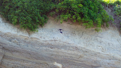
Port Williams bluff with two layers of sediment and 2 pigeon guillemots
A better look at the different sediment layers in the bluff, with bonus pigeon guillemots!

There are many other historic photographs of Port Williams to enjoy in the Bert Kellogg Collection, available for viewing on the Washington Rural Heritage digital archive website or in person at the Port Angeles branch of the North Olympic Library System.