11/30/21

Tall ships in Port Townsend Bay


This 1891 view of Port Townsend Bay is enchanting for so many reasons - the bay loaded with tall ships (and one hybrid steamer), the impressively crafted buildings and docks, and the streetcar in the near frame, and the sand roadways:

1891 view of Port Townsend and Port Townsend Bay.  Image credit:  Bert Kellogg collection.

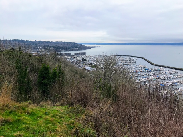
I had a harder time than I expected trying to find the photographer's location, and I'm not sure I've got it right...but the modern view shot from about here next to Port Townsend's Fire Bell Tower seems to make sense, as its not difficult to imagine a photographer setting up (at what would have been a newly built tower site) there ~130 years ago:

9 July 2021 photo

Vegetation obscures much of the historic view, but the scale and size of the tall ships in the historic bay give a sense for the types of changes the waterfront of Port Townsend has scene in the last 130 years.

11/3/21

From Craven Peninsula to Port Townsend Canal

 In 1841 explorer Charles Wilkes named the small stretch of gravel connecting Port Hadlock with Indian Island Craven Peninsula after a member of his crew, Lt Charles Craven.

The peninsula was submerged at high tides. Natives and later settlers portaged over the peninsula at high tides.  

As early as the mid 1800's, there was interest in dredging the peninsula to make the channel a channel for shipping.  

Finally in 1915, the peninsula was dredged and a canal was created.  Local residents were promised a bridge that didn't come until 1952.  Prior, residents and later the Navy on Indian Island used a variety of boats and later ferries to cross the channel.  

Read more about the story of Craven Peninsula, the dredging, ferries and the bridge on this link:

Peninsula Daily News


10/7/21

Restoration and change on the Elwha River delta

 Another perspective on short-term change on the shoreline associated in part with restoration (like this post from June), again on the Elwha River delta (like this post from 2020).  This particular location is on the east side of the Elwha River delta, and was eroding rapidly between 2011 and 2015.  Here is what the site looked like in 2011:

May 2011 photo of the beach on the Elwha River delta, looking up the beach from the low tide line.  

By late 2013 the beach was heavily eroded, revealing large boulders on the beach, part of a failed defensive rip-rap structure built at some point in the past:

September 2013 photo

By Summer of 2016 sand associated with the removal of two dams on the Elwha River was moving through this area, but not in quantities adequate to re-bury those big rip rap boulders, or rebuild the beach to its 2011 position:

July 2016 photo

Later in the summer of 2016, though, those rip-rap boulders were removed as part of a restoration project, and the sediment from the dam removal kept pumping along the beach, so by 2018 the beach looked very different at this location:

July 2018 photo


9/5/21

Mistaken Identity - #2 - Seattle's Alki Point or Orcas Island?

 At least one historical hard cover Seattle photo history book and a HistoryLink post on Alki Point have presented this image as 'A Outing near Alki Point', 1889.  (Alki Point is in Seattle)


When I saw both publications, the image didn't quite feel like Alki or anything near Seattle.  

The large hill or mountain in the background seemed too tall and too close to be in Seattle.  

Often telephoto lenses can squeeze elements together and bring mountains closer to the foreground, but I assume the photographer didn't have a 600mm lens in 1889, even on a view camera.  

So I posted the image on the Facebook group "Puget Sound and Surrounds."  Everyone who responded agreed it's definitely not Seattle.  Maybe Chuckanut Drive, Hood Canal or.. the San Juans? 

It was decided through similar photos and Google Earth that it was Orcas Island!  

Here's the results! 


Post by Emily Wilmot - 


Posted by:
Ivan Dennison
The rocks these people are sitting on are still there (as is the landing on the opposing shore) and visible just to the left of the icon for the Inn.


Mistaken Identity - Blake or Waadah Island?

 I follow the Facebook group History of Puget Sound and Arounds whose followers post common and sometimes less known PNW history photos.  

In November 2019, group admin shared a post from another FB group showing this postcard from the early 20th century showing 'Puget Sound Indians' on the beach after fishing. 

Group members felt the location was Blake Island, across from Seattle.

Right off, I knew it was Waadah Island, which borders Neah Bay.  I've surfed around Neah Bay for years so know the area well.  

When you enter Neah Bay, you can view Waadah Island as you just arrive in town.  The island was connected to the shoreline at some point thus protecting the bay and its fishing fleet from ocean swell.

Below is the postcard and post from the history group.  

Further below are images I found showing the island in different eras including (middle) the image from the book "The Sea is My Country."


8/9/21

Sekiu and the schooner Louise

 This 1909 photo of the schooner Louise S. on its side in Sekiu is featured in an interpretive display about shipwrecks at Clallam Bay State Park, and I've always found it arresting.  

The schooner Louise S. aground just offshore of Sekiu, WA in 1909.  Photo from the Bert Kellogg collection.  

The ship itself provides a glimpse into a time period on the Olympic Peninsula when boats like this would have been a common sight sailing from coastal town to coastal town.  But the other thing, of course, that this photo features is in the background...the shoreline of Sekiu.  And just as the ship speaks to changes in our modes of transport, the shoreline in this 1909 photo speaks to changes in the shoreline.  Here is the modern view from more or less the same spot:

8 August 2021 photo of the boat haven in Sekiu, Washington, taken about here.

The changes here made it hard to orient the photo, but I tried to focus on the iconic Three Sisters (here is a closer-up historical view of them), which are barely visible in the modern photo, sticking out of a parking lot behind the boats.  The shoreline here has been filled and, obviously, a breakwater built to create the modern boat haven.  I can't find much online about the history of the breakwater, fill or the marina in general, so if anybody knows more please reach out.


7/9/21

The Irondale Steel Mill

 This one happened by accident...I happened to be down at the beautiful Irondale County Beach Park with my kids and just decided to poke around the Bert Kellogg collection for photos from Irondale.  I had no idea that this was the site of one of the first major industrial endeavors in Western Washington, the Irondale Iron and Steel Plant built in 1881.  This photo from sometime around the turn of the 20th century gives a sense for the scale of the site:

Turn of the century photo of the Irondale Iron and Steel Mill, taken from about here.  Photo from the Bert Kellogg collection.

The modern view (or as close to it as I could figure out how to get):

5 July 2021 photo taken here.

At low tide various pilings and cement footings are still visible on the beach here, presumably that were associated with the buildings and wharfs of the mill.  And while I didn't explore more of the site, it looks as if there might be a lot of history still visible in the trees if you poke around.  In the distance in both the historic and modern photo is Kala Point, with an apparently nearly identical copse of trees visible in both photos, and then behind that the shoreline of Port Townsend.  


6/27/21

Port Crescent, Revisited from the Water

We’ve posted about the lost logging town of Port Crescent on this blog before, but there are so many great historical photos of the townsite, it’s worth revisiting. This time our view is from the waterside with the 500 ft. wharf and Markham hotel just as prominent as in our previous post.

Port Crescent then (1902) and now (June 2021)

As always, I encourage you to examine the historical photo (another from the Bert Kellogg Collection) on the Washington Rural Heritage website. The most interesting details to me are the train engine on the wharf and the tug tied up at the end of the wharf.

Port Crescent was booming in the late 1800’s, along with many towns on the Olympic Peninsula. At its peak, the town was populated by between 600-700 people. The timber industry and prospects of becoming the terminus of a transcontinental railroad line brought investors and money.

In 1890, three Clallam County towns were in competition to be the country seat, at the time located in New Dungeness. Port Crescent and New Dungeness lost out to Port Angeles and the rest is history. The railroad never came to Port Crescent and neither of the losing towns exist today.   

As a bonus, here is a second view of Port Crescent facing west from the water. You can view the original historical photo here

Port Crescent then (date unknown) and now (June 2021)


References:

6/9/21

The Dungeness Pier, a look to the south

For a while I've been wanting to try to replicate this 1909 photo looking south from  a spot out in Dungeness Bay (about here):

1909 photo looking south, taken from the deck of the old Dungeness pier.  Photo from the Burt Kellogg collection.  

There are a few things that are just arresting about this photo - notably that its a panorama view, made of multiple photos physically aligned and presumably taped or glued together, and that it was taken from the now-gone Dungeness pier.  The pier was really quite long...3/4 mile when it was originally built in 1890-91...and it really had to be to reach deep water at the edge of the active delta of the Dungeness River.  This pier was the key bit of infrastructure connecting the products derived from forests, ag land and waterways of the Sequim prairie to the rest of the world, and the pier served the larger cargo boats and ferries that were calling at Dungeness at the time.

I finally had the chance today to try to recreate this view while I was on my way out to Dungeness Spit by boat:

9 June 2021 photo looking south from the water...

Its actually quite hard to confirm that I've got it exactly right...but its close at least.  The mountains provide good clues in the background, but today's clouds obscured some key summits.  Interestingly its really quite hard to place some of the closer landscape features in the historic photo, perhaps because the landscape has changed so dramatically in this area (it is, after all, an active river delta).  This paper by the University of Washington's Brian Collins is a really fascinating and rich description of those changes...and well worth a look, if not a full read.  

 According to this article the dock served a useful life for about 50 years, after which it decayed until its removal as part of a restoration project in 2018-19.  Its still visible in many aerial photographs, and of course blog co-conspirator Shanon Dell had the same idea as I did, but acted on it much sooner, collecting this photo in December 2014, before the pier remnants were removed:

December 2014 photo by Shanon Dell


5/4/21

The Twin "Mole"

Looking west in 2010 from about here on the Strait of Juan de Fuca.  Photo by Hugh Shipman 

This weekend I took advantage of the good low tides to trek out west for a walk on the fascinating shoreline near the West Twin River.  A notable feature on this shoreline used to be the "mole" that served a former clay mine that is currently owned by LaFarge North America, and which is the low, pier-like feature in Hugh Shipman's 2010 photo above.  This mole was indeed used as a wharf, to load barges of mine material when the mine was active.  In 2016 the company removed the mole as part of the requirements associated with their aquatic lands lease, and the Coastal Watershed Institute was contracted and designed a removal approach relying largely on natural erosion to re-distribute the fill material making up the core of the mole.  As a result Hugh Shipman's 2010 view looks quite a bit different:

1 May 2021 photo looking west at the former site of the LaFarge clay mine mole.

This is another example of a very short-term, restoration-driven change to the shoreline, similar to the Elwha restoration example posted here.  

4/15/21

Changing uses of the shoreline: The Coupeville wharf


A few weeks ago during a brief ice cream stop-over in Coupeville, Washington, I spent a few minutes appreciating the nice little wharf that is a central feature of town.  The wharf appears to be primarily given over to tourist use, and the building at the end features public restrooms, and a few small shops.  A quick bit of time online, though, revealed that this view I was enjoying was yet another prime example of the changing uses of Washington's shorelines that feature in previous posts.  In particular, I found this 1933 photo of the wharf on the Port of Coupeville website:


The wharf was built in 1905 and, not surprisingly, supported the transportation needs of a variety of industries for many decades.  In the photo above, for example, a grain tower is visible on the left side (photo perspective) of the building, to support the loading of grain, and the wharf also acted as a ferry landing until the Deception Pass Bridge was built in the 1930's.  It wasn't until the mid 1980's that the wharf slowly started to transition into something more like a tourist destination.  The Port of Coupeville's website also features a really nice history of this wharf, and its changing uses through time - nearly all of the information for this post came from that site.  

3/20/21

Another view of New Dungeness Lighthouse

We’ve visited New Dungeness Lighthouse in a previous post, but it’s such a unique spot, it’s worth looking at from multiple angles. My bucket list goal for this blog is to find a historical photo taken from the top of the lighthouse that looks out toward the end of Dungeness Spit. The reason? Due to the erosion of nearby bluffs and the currents in the Strait of Juan de Fuca that carry the eroded material to the east, Dungeness Spit lengthens by around 15 feet per year. When built in 1857, the lighthouse was only 900 feet from the end of the spit. It’s now more than a half mile from the end. I hope to someday find a historical photo that will allow us to document that growth.

In the meantime, our now and then photos show some of the changes that occurred at the lighthouse itself, which has also evolved significantly over time.

Historical and current view of New Dungeness Lighthouse
Then: 1896, courtesy National Archives / Now: Feb. 2021

Yes, those photos are of the same lighthouse. The tower was lowered in 1927 due to deterioration of the brickwork. So the dark section above is now gone. Many other buildings have been added and subtracted since our Then photo was taken in 1896. Most notably, the keeper’s home was added in 1904 (on the right in the Now photo).

My now photo is from a perspective a little lower in the water then the then photo because I was shooting while sitting on my paddleboard and I presume the historical photo was taken from a boat with a much higher deck.

Seeing the outer fence in the historical photo reminded me of my favorite New Dungeness Lighthouse story. It’s from a book written by James C. Isom, published by the New Dungeness Light Station Association, and aptly titled, History of the New Dungeness Lighthouse. The book tells us that keeper E.A. Brooks (1902-1925) kept cows and sheep on the spit, and apparently the cows weren’t too happy with the location:

“Several keepers likely had cows on the spit, particularly if there were small children…The Brooks family had a cow that would sometimes swim to the mainland in search of better grass. The boys would have to find the cow and drag it home for milking.”

If I was paddling out to the lighthouse and passed a cow headed for the mainland, I think I might have to give up paddling. 😊

Sources: 

https://www.sequimgazette.com/news/mother-nature-and-the-dungeness-spit/
https://newdungenesslighthouse.com/the-lighthouse/
https://catalog.archives.gov/id/45708329?&sp=%7B%22q%22%3A%22dungeness%22%7D&sr=1

3/17/21

Changing beaches: Kalaloch

2 March 2014 photo taken of beach wood at the base of coastal bluffs on Kalaloch Beach in Olympic National Park. 


This post is a bit different, in that it focused on changes to shorelines over very short time-scales...a few years, probably driven by forces that don't have anything to do, at least directly, with people.  It will hopefully come as no surprise that shorelines are one of the most ever-changing landscapes on the planet, subject to pushes and pulls from both the water and the land.  They change all the time, so on some level it shouldn't come as any surprise that Kalaloch Beach in Olympic National Park has changed dramatically in the past few years.  I wanted to focus on the huge logs that are a very notable feature on the shorelines of Washington State, particularly on the north coast, and that used to pile up at the top of the beach near Kalaloch Lodge.  At some point in 2015, the logs accumulated on the beach near Kalaloch Lodge were stripped away, and haven't yet returned:

12 March 2021 photo of coastal bluffs on the beach near Kalaloch Lodge.

We still don't really understand why they were stripped off the beach here, and probably more importantly, why new large wood hasn't recruited back to the beach.  Its also not clear if the obvious erosion of the bluff at this location has anything to do with the removal of the large wood.  All that we know is that, in the space of just a few short years, the beach looks very different.


3/4/21

Duwamish River - A River with Big Change


The Duwamish River was straightened in 1913 after thousands of years as a natural flowing river whose tributaries originate below Mt Rainier.  

Home to the Duwamish people, Herring's House at the mouth to the now Elliott Bay had at least four longhouses and a huge potlatch house.  

Below is the Waterlines Project map sponsored by the Burke Museum.  The green dots are village sites. Blue are 'named places' or places of importance along the shoreline.  View the full map here

The below comparison is from the Duwamish River Clean-up Coalition page, view it here.


Read More about the Duwamish.. 

Native Seattle, Coll Thrush, UW Press

The River that Made Seattle, BJ Cummings, UW Press

Once and Future River, UW Press

Too High Too Steep, David Williams, UW Press

Chief Seattle, David Buerge, Sasquatch Books 


2/22/21

Hollywood Beach in Port Angeles, changing uses of the shoreline

Last year I posted a set of before/after photos of Hollywood Beach in Port Angeles, with a focus on how much large-scale fill has transformed Washington's urban shorelines.  This post is going to focus on the same area, but I'm going to try to emphasize the trade-offs, from a cultural and ecological stand-point, associated with that transformation.  I feel that this particular photo:

does this job well.  This photo, taken from right about here, ended up in my collection, but I don't know a whole lot about it...when it was taken, whose collection its in, etc. (and who should be credited for it; please get in touch with me if you know anything about it).  But this photo was definitely shot before downtown Port Angeles was filled around 1913, and gives us some perspective of both the uses (residences, canoes, etc.) and habitat conditions (a relatively broad, low-sloping beach and actively eroding coastal bluff) of this shoreline.  The view from this perspective is now radically different:

June 2015 photo looking east along the historic shoreline near Hollywood Beach in Port Angeles

These two photos aren't perfectly aligned, but are pretty close...


2/1/21

Seattle's Ballard Beach Pre-Shilshole Marina and Present Day

Seattle experienced big changes along it's shorelines in the 20th century.  In Ballard, Shishole Bay went from a rural gravel covered beach with forested hillsides to fully developed with filled in shores, pavement and residential areas.  

Ballard Beach pre-road (looking North to Golden Gardens)


Ballard Beach, 1920's looking South


Burke Gilman link, Seaview Ave and Shilshole Marina, 2021


Ballard Beach looking southwest towards the entry to Salmon Bay, Magnolia and West Point


From 34th NW street overlooking Shilshole Marina, approx 1960's, early marina days.


                               From the 34th NW St park overlooking Shilshole Marina 2021

1/31/21

Seattle's West Point Lighthouse - 1940 and 2021

I came across this 1940 photo in one of the Magnolia Historical Society's books 'Magnolia Memories'.  

What's significant about it is that it's before the sanitation facility was installed in the 1960's. 

History Link states "This low sand spit, made by the opposing currents on the sound, was known to the Duwamish Indians by "Per-co-dus-chule," or "Pka-dzEltcua," which translates "thrusts far out." It was known to early mariners as Sandy Point."  If you have flash, this is a great history of West Point link.

The shoreline is untouched on the south and north sides and the point aside from the 1881 era lighthouse depicts the other low points with a salt marsh seen elsewhere around the Sound such as Marrowstone Point. 

Lighthouse Friends points out that Seattle's raw sewage poured out onto the seemingly pristine beaches making for quite a stink. 

The young man in the photo probably didn't know what was coming his way with WW2 starting in the US later the next year.   

As a paddle surfer, I like the boat wakes in the lower left image probably by the boat that just passed the point upper right.  These days we surf small and freighter size surf along West Point.  


The now image isn't as exciting. Bluff erosion and heavy foliage kept me from being more to the left as the before image depicts.  I shot the image in January for better visibility through the trees.  

There's a path with a wooden railing leading to the view from the main road.  


Google Earth cropped view from (5/26/2018).  North -->

Posted by Rob Casey, 1/21


1/6/21

English Camp Blockhouse and shoreline

The Blockhouse at English Camp on San Juan Island.  Photo collected 2 December 2020

I first visited English Camp in the early 1990's as a college student on a spring break bike trip.  I was as struck then as I am now by what is known as the Blockhouse, sitting on the wet marshy edge of  Garrison Bay.  This building dates to the 1860's and is notable both for its design and location, which strikes as me as fairly unique for the Pacific Northwest, and also for its relatively good state of repair given its location in the upper intertidal.  If you pulled up to this shoreline around 1915 you would have been greeted by a very similar view of the Blockhouse:

Photo of the Blockhouse, circa 1915.  Photo from the University of Washington Special Collection.

The building is treated well now, as it is managed by the National Park Service, but it is astonishing that it survived through many decades of private ownership between when the English departed in 1876, and when the NPS took over the management of this site in the 20th century.  The 1915 photo above was taken after at least 30 years of the site and buildings being used as a homestead and farm, with the waters of Garrison Bay lapping at the base of the structure the whole time.