Showing posts with label maritime history. Show all posts

11/14/22

Tillicum towing Kitsap out of Ballard, 1916

 I spend a lot of time paddling and walking the shorelines of Seattle's Salmon and Shilshole Bays and thinking about now and then perspectives.  

While browsing the Seattle Public Library Special Collections online last night I came across these images I've never seen before titled - Tillicum towing Kitsap out of Ballard, 1916 (spl_shp_40570)

And just behind the Kitsap is a dredger probably working to clear a channel below the newly constructed Ballard Locks just upstream.  

The image is shot from Magnolia looking NE towards Ballard and Sunset Hill. 


For me, there's a lot going on in these image. It's not just a majestic ship being towed out of Salmon Bay but I wonder if the foreground is Salmon Bay Charlie's (Hwehlchtid) land protruding into the channel before it was dredged?  


In the horizontal image the train bridge at NW 61st St is a bit further down to right suggesting that this could be Charlie's later dredged spot.  

Comparing a popular image of his place (below), the large cleanly cut beach log in the foreground looks familiar.  But this image is in 1905 and the Kitsap images (above) are 1916. The above images face the opposite direction.  

1905, Webster and Stevens Studio, UW Libraries.

I've been researching the Ballard shoreline where I spend a lot of time in the Elks Lodge and adjacent beach as an Elks Member and for my paddling business, Salmon Bay Paddle. The Elks Lodge would be built in the 1960's in the space between the dredger and the Kitsap.  

And further in the distance on the hill above the now Golden Gardens Park is a full growth of probably old growth trees, unlike the scene further to the south or (right) which was mostly logged in the 1870's. 


6/27/21

Port Crescent, Revisited from the Water

We’ve posted about the lost logging town of Port Crescent on this blog before, but there are so many great historical photos of the townsite, it’s worth revisiting. This time our view is from the waterside with the 500 ft. wharf and Markham hotel just as prominent as in our previous post.

Port Crescent then (1902) and now (June 2021)

As always, I encourage you to examine the historical photo (another from the Bert Kellogg Collection) on the Washington Rural Heritage website. The most interesting details to me are the train engine on the wharf and the tug tied up at the end of the wharf.

Port Crescent was booming in the late 1800’s, along with many towns on the Olympic Peninsula. At its peak, the town was populated by between 600-700 people. The timber industry and prospects of becoming the terminus of a transcontinental railroad line brought investors and money.

In 1890, three Clallam County towns were in competition to be the country seat, at the time located in New Dungeness. Port Crescent and New Dungeness lost out to Port Angeles and the rest is history. The railroad never came to Port Crescent and neither of the losing towns exist today.   

As a bonus, here is a second view of Port Crescent facing west from the water. You can view the original historical photo here

Port Crescent then (date unknown) and now (June 2021)


References:

8/24/20

Ballard Shoreline Aerial Comparisons - 1940 and 2020

 Here's a fun comparison of the 1940's Ballard / Seattle shoreline and the current view from Google Earth.  

The now view is of the Seaview Avenue shoreline at the entry to Salmon Bay and Shilshole Bay at the location of the now Ray's Boathouse, former Anthony's, Ballard Elks Club, Sunset West Condos and the south corner of Shilshole Bay Marina.  

The bit of land across the channel is the NE corner of the Magnolia neighborhood.  

The 1940 view shows a different less developed shoreline with the reindeer ship, the SS Bering beached in front of the now Elks Club.  In the 1940's, the Tregoning Boat Company was located there.  

I believe the Ballard ferry landing was just south of (or above here) of Ray's Boathouse (to Port Ludlow and Suquamish).

The older photo also shows more beach homes across from Seaview Ave. Only a few are left now along with a few condos and misc buildings.  

From a surfing perspective, Point Shilshole is the point of land jutting out in the older photo. There's a nice wind swell rolling in and whitewater just offshore and along the shore.  

Looks like a good surf spot. We surf freighter and wind waves on Shilshole Bay so without the extra development and marina, we'd have one more downwinding and shore break spot!


Below is a Now and Then view from the Ballard Elks Lodge with the SS Bering looking out into Shilshole Bay. The ship was burned to make way for development in the early 1960'.  Now view from the Ballard Elks Sunset Cam.


8/8/20

Ballard Boat Works 1905 and Present

Sivert Engelsen Sagstad, a young Norwegian boat builder emigrated to Seattle and opened Ballard Boat Works, pictured here on lower Salmon Bay, pre-Locks in 1905.

I paddle past this shoreline weekly and have been trying to look for any early evidence of his boatyard and as well as any Shilshole tribal evidence which was prevalent along the shoreline prior to the boatyard.

When the Ballard Locks were being developed some of the shoreline below the boatyard was removed. In the 1905 mage, note that the shoreline had a gentle slope to the water.  In the Now images, the shoreline is shorter and abruptly drops to the water. 

Read more about Sagstad and the 70' Viking ship replica in this article from HistoryLink..  Read the HistoryLink story 

Now view from Seaview Picnic Park

Ballard Boat Works in 1905 and 'Now' view from Seaview Picnic Park

'Now' view from Seaview Picnic Park (location of yellow arrow)

2020 view of approx Ballard Boat Works location.  Photo: Salmon Bay Paddle


8/5/20

Dungeness Spit: The Lighthouse, Part 1

Yesterday I wrapped up the last of three days of annual shoreline survey work on Dungeness Spit, which took me out to the lighthouse area.  The scene here is completely different than what you find on Ediz Hook, in the sense that visiting the lighthouse on Dungeness Spit is a lesson in constancy...at least over the historical period.  Here is what I mean.  This is a photo from the turn of the century (exact date unknown) of the lighthouse complex on the end of Dungeness Spit:
Turn of the century photograph of the New Dungeness Lighthouse, originally built in 1857.  Photo from the Bert Kellogg collection, hosted by the North Olympic Library System.  

Here is roughly the same view (I didn't get the perspective quite right), approximately 120 years later:
7 June 2020 photograph of the New Dungeness Lighthouse.

Its amazing to me how much is similar between these two photos.  I'm sure there is a long story behind how this amazing set of structures has been preserved, but my suspicion is that a lot of the credit probably goes to the New Dungeness Light Station Association, an organization dedicated to the maintenance of this place.  

There are, of course, some interesting differences that I didn't note until I had the chance to examine these photos carefully.  First off, the light tower itself is shorter...apparently due to a tower shortening project conducted in 1927 (see the history assembled here).  A few buildings are missing - a fog signal building and privy, for example, that are shown in the historic image above aren't in the modern view.  In the historic view you can also make out a tram on rails that ran to a dock, and was used for transporting supplies from off-loading ships to the lighthouse.  There is no trace of that tram in the modern photo above though you can find bits and pieces of it still scattered in the adjacent dunes:
4 August 2020 photo looking east from a point west of the New Dungeness Lighthouse, showing what I take to be pieces of an old tram used to move supplies between a dock and the lighthouse.

6/11/20

Washington Harbor - 600 Years of Activity

This Washington Harbor shoreline at the entrance to Sequim Bay is one of the most culturally significant and extensively researched historical locations in the Sequim-Dungeness area. The few acres of land shown here were home to a S’Klallam Tribal village for at least 600 years, a clam cannery for more than a half-century, and is now utilized for research in marine sciences.  

Then - Bugge Clam Cannery, approx. 1905-1910 
(Courtesy the Burt Kellogg Collection of the North Olympic Library System)  
Now - Pacific Northwest National Laboratory, May 2020

The historical photo is one of many taken of the Bugge Clam Cannery and available for viewing in the Burt Kellogg Collection of the North Olympic Library System. The cannery operated at Washington Harbor as early as the 1880s and a large Victorian home was built in 1889 (at far right). Sequim pioneer Hans J. Bugge is the most notable developer at the site.  Hans, and later his son Anphin, operated the cannery here for more than 60 years. The cannery had 30-40 employees and at its peak, shipping 10,000 cases of clams per year under the names Moon Kist and Tureen.

Bugge Clam Cannery at Washington Harbor,
with Bugge's Georgian-style home
Courtesy of the North Olympic History Center
The site also included a creamery (1905-1917) and the dock served as the primary port for commercial ships of the Mosquito Fleet until the wharfs at Port Williams and Dungeness were built. Children arrived by boat to a small schoolhouse that also sat on the property until it was moved to a nearby hillside due to winter tidal flooding. In 1910, Hans Bugge replaced the previous home on the site with a 6-bedroom Georgian style home which stood well into the time period of the next owners, Battelle.  

In 1966, Battelle Northwest purchased the property and developed it into a marine research laboratory and continues to operate at the site today as Pacific Northwest National Laboratory, operated by Battelle for the Department of Energy.

The S’Klallam village sxʷčkʷíyəŋ occupied this same site for approximately 600 years, until the late 1880s. The town of Sequim takes its name from this village, which translates to “place for going to shoot,” reflecting the abundant opportunities for hunting. There are a handful of cedar posts on the beach today that remain from that era (far left in the pictures but too small to see). They can be easily spotted from a standup paddleboard or kayak as you paddle along the shoreline.

Cover of Jamestown S'Klallam Tribe's history of the village at Washington Harbor

The most comprehensive and easily accessible telling of the Tribe’s history here was prepared by Jamestown S’Klallam Tribe’s Cultural Resources Specialist David Brownell and is available as an ebook pdf from the Tribal library.   


6/4/20

The SS Bering, a Reindeer Ship in Ballard

The SS Bering was a ship that was parked on the beach at Point Shilshole, now the home of the Ballard Elks Lodge. The Bering was built originally as the Annette Rolph at Fairhaven, California in 1918. The ship later spent time as a tramp steamship, reindeer ship, refrigerator ship and supply ship to Alaska during WW2.

In 1964, she was burned by the local fire department to make way for new development. Soon thereafter, the Ballard Elks Lodge was built on the site.


.
Now view from the Ballard Elks webcam.

In 1943, she ran aground on Cape Spencer. Her crew re-floated her. Seattle based Tregonning Boat Company bought her for $1 and proceeded to beach her at their facility on Point Shilshole where she sat for the next two decades.  

A piece of the hull can still be seen at extreme low tides (-3 ish).  I launch my kayaks and SUPs from that location nearly daily and still see pieces of the ship on the beach. About a decade ago, a guy was removing larger pieces from the ship to clean the beach. The pieces generally look like burnt looking wood planks covered in barnacles. 


Read more about the SS Bering in this great HistoryLink article.   See my article on the Ballard Elks Lodge history.

The location of the Ballard Elks is 6411 Seaview Ave NW, Seattle. 


By Rob Casey / Ballard


5/5/20

Port Williams...Bustling Port Now County Park

Port Williams is located on the Olympic Peninsula near Sequim, between Sequim Bay and New Dungeness Lighthouse. It’s currently a Clallam County park with a boat ramp and wonderful beach combing opportunities. But in the late 1800s and into the early 1900s, this spot served as a port for Mosquito Fleet steamers that were providing supplies and transportation to the new settlers of the Sequim prairie. The wharf was built in 1890 and included a hotel, restaurant, post office, store and dance hall. The Port Williams townsite was abandoned in 1922.

Port Williams - Then (early 1900s) and Now (2020)

The historic image is courtesy of the Museum and Arts Center in Sequim-Dungeness. The exact date is unknown, but the ship, the Alice Gertrude, was built in 1898 and ended its run in Clallam Bay, running aground during a snowstorm in 1907.

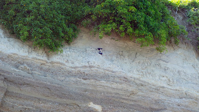
It’s interesting to note the dark stripe that runs horizontally, halfway up the bluff in both photos. This is the result of glacio-lacustrine deposits, sediment that settled in glacial meltwater during the Vashon glaciation period. More than 14,000 years ago, the Cordilleran glacial ice sheet, measuring at least 3000 feet deep, covered most of Western Washington. As it advanced and retreated, the glacier carved much of Puget Sound into the landforms and waterways we see today. It also left us with timeless features to match up in then and now photographs of our ever-eroding bluffs.

Port Williams bluff with two layers of sediment and 2 pigeon guillemots
A better look at the different sediment layers in the bluff, with bonus pigeon guillemots!

There are many other historic photographs of Port Williams to enjoy in the Bert Kellogg Collection, available for viewing on the Washington Rural Heritage digital archive website or in person at the Port Angeles branch of the North Olympic Library System.