11/25/20

Turn Point Light Station

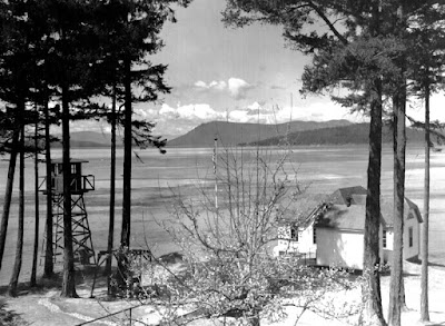
WWII era photo of the Turn Point light station, with a military observation tower in the left of the image.  Image from Wikimedia Commons

Turn Point on Stuart Island marks the ragged and liquid edge of the contiguous United States, and like many of the most northerly rocky points of the San Juan Islands, it is graced with a historic lighthouse that helped (and still helps, though now with an automated light) to guide ships along the channels between Canada and the United States.  And, like many of the historic light stations, it is in very good repair, such that if you were a visitor to this place from the turn of the century you might not immediately know that you had arrived in 2020.  Case in point, the image above is ~80 years old, and the scene today is different only in minor detail:

1 November 2020 photo of the Turn Point light station, looking north from the Keeper's house

The most notable difference is the observation tower at left in the photo, which was used as an observation post during WWII...another symbol of changing uses of Washington's shoreline.

11/18/20

Friday Harbor Laboratories, an early version


Photo of one of the early iterations of what is now the University of Washington's Friday Harbor Labs.  Photo courtesy of the University of Washington's Special Collections.

The photo above dates to between 1909 and 1924, and is of a location on the shorelines of Friday Harbor on San Juan Island (about here).  The building in the forefront of the photo still sits on the shoreline, and was used as one of the early sites of what has become the University of Washington's Friday Harbor Labs.  My guess is that those tents perched on the hillside hosted students, and according to the history linked above, the site was eventually abandoned in favor of the Lab's current location here due to the steepness and muddiness of this location.  That steepness and muddiness, though, did not prevent the site from developing through time, though, and those tents have been replaced with some very high value real estate on the outskirts of the town of Friday Harbor.  Here is the contemporary view:

15 November 2020 photo of the shoreline of Friday Harbor, Washington


11/13/20

Landing craft on the beach at Fort Worden

 A quick post today from Fort Worden in Port Townsend. I mostly want to use this post to amplify the great work by Fort Worden historian Tim Caldwell with his regular column in the Port Townsend Leader newspaper. Kudos to the newspaper and the community for continuing to celebrate and share the story of this special place. 

Tim shared this same historical photo of landing craft on the beach at Point Wilson earlier this year. Please enjoy Tim's history behind this photo at the Port Townsend Leader's website and enjoy my now photo here for comparison:

Point Wilson at Fort Worden Then (1950) and Now (2020)
(Historical photo courtesy of the Jefferson County Historical Society)

In the distance you see the Point Wilson lighthouse, which has stood since 1879, although it was rebuilt in 1914. It was built on a very sandy beach and the shoreline to the north was heavily armored in an effort to protect the lighthouse and associated buildings from the large wind waves from the Strait of Juan de Fuca that pummel the beach and threatened the integrity of these structures. The negative effects of shoreline armoring obviously weren't known in those days. 

Please visit this page from the National Archives to see photos of the previous lighthouse and the beach before the riprap was placed. For more information about the history of the lighthouse, please visit lighthousefriends.com, and for current information please visit pointwilsonlighthouse.org


: