Showing posts with label Olympic Peninsula. Show all posts

6/14/22

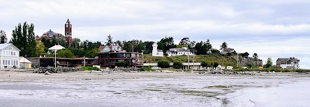
Port Townsend Shoreline in 1792 and 2022

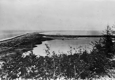
 In 1792, Captain Vancouver camped at Port Hudson in now Port Townsend to explore the area in 3 small boats.  

John Sykes illustrated this image showing the SE part of 'PT' with his crew in a canoe and native bird catching nets in the background.  

Spending some time in PT recently, I had the opportunity to get the 2022 photo at a minus tide in front of the Aladdin Hotel where we were staying during the Seventy48 and R2AK race weekend and 'Ruckus'.  

Read more about this visit by Captain Vancouver on the History Link site.. 

These images face East..


                                       Poles supporting nets to catch ducks, Port Townshend, 1792

                                    Engraving by John Sykes, Courtesy UW Special Collections (Neg. NA3984)


Taken in front of the Aladdin Hotel, minus tide 6/13/22


Wider view


11/30/21

Tall ships in Port Townsend Bay


This 1891 view of Port Townsend Bay is enchanting for so many reasons - the bay loaded with tall ships (and one hybrid steamer), the impressively crafted buildings and docks, and the streetcar in the near frame, and the sand roadways:

1891 view of Port Townsend and Port Townsend Bay.  Image credit:  Bert Kellogg collection.

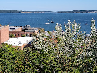
I had a harder time than I expected trying to find the photographer's location, and I'm not sure I've got it right...but the modern view shot from about here next to Port Townsend's Fire Bell Tower seems to make sense, as its not difficult to imagine a photographer setting up (at what would have been a newly built tower site) there ~130 years ago:

9 July 2021 photo

Vegetation obscures much of the historic view, but the scale and size of the tall ships in the historic bay give a sense for the types of changes the waterfront of Port Townsend has scene in the last 130 years.

6/27/21

Port Crescent, Revisited from the Water

We’ve posted about the lost logging town of Port Crescent on this blog before, but there are so many great historical photos of the townsite, it’s worth revisiting. This time our view is from the waterside with the 500 ft. wharf and Markham hotel just as prominent as in our previous post.

Port Crescent then (1902) and now (June 2021)

As always, I encourage you to examine the historical photo (another from the Bert Kellogg Collection) on the Washington Rural Heritage website. The most interesting details to me are the train engine on the wharf and the tug tied up at the end of the wharf.

Port Crescent was booming in the late 1800’s, along with many towns on the Olympic Peninsula. At its peak, the town was populated by between 600-700 people. The timber industry and prospects of becoming the terminus of a transcontinental railroad line brought investors and money.

In 1890, three Clallam County towns were in competition to be the country seat, at the time located in New Dungeness. Port Crescent and New Dungeness lost out to Port Angeles and the rest is history. The railroad never came to Port Crescent and neither of the losing towns exist today.   

As a bonus, here is a second view of Port Crescent facing west from the water. You can view the original historical photo here

Port Crescent then (date unknown) and now (June 2021)


References:

3/20/21

Another view of New Dungeness Lighthouse

We’ve visited New Dungeness Lighthouse in a previous post, but it’s such a unique spot, it’s worth looking at from multiple angles. My bucket list goal for this blog is to find a historical photo taken from the top of the lighthouse that looks out toward the end of Dungeness Spit. The reason? Due to the erosion of nearby bluffs and the currents in the Strait of Juan de Fuca that carry the eroded material to the east, Dungeness Spit lengthens by around 15 feet per year. When built in 1857, the lighthouse was only 900 feet from the end of the spit. It’s now more than a half mile from the end. I hope to someday find a historical photo that will allow us to document that growth.

In the meantime, our now and then photos show some of the changes that occurred at the lighthouse itself, which has also evolved significantly over time.

Historical and current view of New Dungeness Lighthouse
Then: 1896, courtesy National Archives / Now: Feb. 2021

Yes, those photos are of the same lighthouse. The tower was lowered in 1927 due to deterioration of the brickwork. So the dark section above is now gone. Many other buildings have been added and subtracted since our Then photo was taken in 1896. Most notably, the keeper’s home was added in 1904 (on the right in the Now photo).

My now photo is from a perspective a little lower in the water then the then photo because I was shooting while sitting on my paddleboard and I presume the historical photo was taken from a boat with a much higher deck.

Seeing the outer fence in the historical photo reminded me of my favorite New Dungeness Lighthouse story. It’s from a book written by James C. Isom, published by the New Dungeness Light Station Association, and aptly titled, History of the New Dungeness Lighthouse. The book tells us that keeper E.A. Brooks (1902-1925) kept cows and sheep on the spit, and apparently the cows weren’t too happy with the location:

“Several keepers likely had cows on the spit, particularly if there were small children…The Brooks family had a cow that would sometimes swim to the mainland in search of better grass. The boys would have to find the cow and drag it home for milking.”

If I was paddling out to the lighthouse and passed a cow headed for the mainland, I think I might have to give up paddling. 😊

Sources: 

https://www.sequimgazette.com/news/mother-nature-and-the-dungeness-spit/
https://newdungenesslighthouse.com/the-lighthouse/
https://catalog.archives.gov/id/45708329?&sp=%7B%22q%22%3A%22dungeness%22%7D&sr=1

11/13/20

Landing craft on the beach at Fort Worden

 A quick post today from Fort Worden in Port Townsend. I mostly want to use this post to amplify the great work by Fort Worden historian Tim Caldwell with his regular column in the Port Townsend Leader newspaper. Kudos to the newspaper and the community for continuing to celebrate and share the story of this special place. 

Tim shared this same historical photo of landing craft on the beach at Point Wilson earlier this year. Please enjoy Tim's history behind this photo at the Port Townsend Leader's website and enjoy my now photo here for comparison:

Point Wilson at Fort Worden Then (1950) and Now (2020)
(Historical photo courtesy of the Jefferson County Historical Society)

In the distance you see the Point Wilson lighthouse, which has stood since 1879, although it was rebuilt in 1914. It was built on a very sandy beach and the shoreline to the north was heavily armored in an effort to protect the lighthouse and associated buildings from the large wind waves from the Strait of Juan de Fuca that pummel the beach and threatened the integrity of these structures. The negative effects of shoreline armoring obviously weren't known in those days. 

Please visit this page from the National Archives to see photos of the previous lighthouse and the beach before the riprap was placed. For more information about the history of the lighthouse, please visit lighthousefriends.com, and for current information please visit pointwilsonlighthouse.org


:


8/5/20

Dungeness Spit: The Lighthouse, Part 1

Yesterday I wrapped up the last of three days of annual shoreline survey work on Dungeness Spit, which took me out to the lighthouse area.  The scene here is completely different than what you find on Ediz Hook, in the sense that visiting the lighthouse on Dungeness Spit is a lesson in constancy...at least over the historical period.  Here is what I mean.  This is a photo from the turn of the century (exact date unknown) of the lighthouse complex on the end of Dungeness Spit:
Turn of the century photograph of the New Dungeness Lighthouse, originally built in 1857.  Photo from the Bert Kellogg collection, hosted by the North Olympic Library System.  

Here is roughly the same view (I didn't get the perspective quite right), approximately 120 years later:
7 June 2020 photograph of the New Dungeness Lighthouse.

Its amazing to me how much is similar between these two photos.  I'm sure there is a long story behind how this amazing set of structures has been preserved, but my suspicion is that a lot of the credit probably goes to the New Dungeness Light Station Association, an organization dedicated to the maintenance of this place.  

There are, of course, some interesting differences that I didn't note until I had the chance to examine these photos carefully.  First off, the light tower itself is shorter...apparently due to a tower shortening project conducted in 1927 (see the history assembled here).  A few buildings are missing - a fog signal building and privy, for example, that are shown in the historic image above aren't in the modern view.  In the historic view you can also make out a tram on rails that ran to a dock, and was used for transporting supplies from off-loading ships to the lighthouse.  There is no trace of that tram in the modern photo above though you can find bits and pieces of it still scattered in the adjacent dunes:
4 August 2020 photo looking east from a point west of the New Dungeness Lighthouse, showing what I take to be pieces of an old tram used to move supplies between a dock and the lighthouse.

6/17/20

Ediz Hook Part Two - From the Other End

Every year I try to make it out the the end of Ediz Hook to collect survey data to add to a multi-year monitoring study of beaches in Washington State.  Since the whole of the end of the Hook is part of a US Coast Guard base, its not just a simple matter of driving out there...it takes a bit of set up.  But its always fun and interesting.  My trip out there this year was last week, and I figured it also offered a stellar opportunity to provide some perspective on changes to the Hook to complement my earlier post on Ediz Hook.  Notably, the end of Ediz Hook used to host a lighthouse, built in 1865 and subsequently modified a few times.  For this post I want to focus on this photo, dated to the 1880's and presumably shot from the lighthouse tower, looking landward along the Hook:

Photo taken in the 1880's looking landward along Ediz Hook.  From the Burt Kellogg collection, hosted by the North Olympic Library System.  
There really isn't much trace of the lighthouse or its associated buildings out at the end of Ediz Hook anymore, but there are a few more modern storage buildings...and one of them has a flight of stairs that allowed me to get up pretty close to where this photo was shot ~140 years ago.  Here is what the view looks like now:

Photo by Ian Miller, collected 9 June 2020
Ediz Hook is so heavily modified...you have to really use your imagination to get a sense for what an amazing habitat it must have been.  I would love to be able to go back to when the 1880's photo above was shot and take a look around.

6/11/20

Washington Harbor - 600 Years of Activity

This Washington Harbor shoreline at the entrance to Sequim Bay is one of the most culturally significant and extensively researched historical locations in the Sequim-Dungeness area. The few acres of land shown here were home to a S’Klallam Tribal village for at least 600 years, a clam cannery for more than a half-century, and is now utilized for research in marine sciences.  

Then - Bugge Clam Cannery, approx. 1905-1910 
(Courtesy the Burt Kellogg Collection of the North Olympic Library System)  
Now - Pacific Northwest National Laboratory, May 2020

The historical photo is one of many taken of the Bugge Clam Cannery and available for viewing in the Burt Kellogg Collection of the North Olympic Library System. The cannery operated at Washington Harbor as early as the 1880s and a large Victorian home was built in 1889 (at far right). Sequim pioneer Hans J. Bugge is the most notable developer at the site.  Hans, and later his son Anphin, operated the cannery here for more than 60 years. The cannery had 30-40 employees and at its peak, shipping 10,000 cases of clams per year under the names Moon Kist and Tureen.

Bugge Clam Cannery at Washington Harbor,
with Bugge's Georgian-style home
Courtesy of the North Olympic History Center
The site also included a creamery (1905-1917) and the dock served as the primary port for commercial ships of the Mosquito Fleet until the wharfs at Port Williams and Dungeness were built. Children arrived by boat to a small schoolhouse that also sat on the property until it was moved to a nearby hillside due to winter tidal flooding. In 1910, Hans Bugge replaced the previous home on the site with a 6-bedroom Georgian style home which stood well into the time period of the next owners, Battelle.  

In 1966, Battelle Northwest purchased the property and developed it into a marine research laboratory and continues to operate at the site today as Pacific Northwest National Laboratory, operated by Battelle for the Department of Energy.

The S’Klallam village sxʷčkʷíyəŋ occupied this same site for approximately 600 years, until the late 1880s. The town of Sequim takes its name from this village, which translates to “place for going to shoot,” reflecting the abundant opportunities for hunting. There are a handful of cedar posts on the beach today that remain from that era (far left in the pictures but too small to see). They can be easily spotted from a standup paddleboard or kayak as you paddle along the shoreline.

Cover of Jamestown S'Klallam Tribe's history of the village at Washington Harbor

The most comprehensive and easily accessible telling of the Tribe’s history here was prepared by Jamestown S’Klallam Tribe’s Cultural Resources Specialist David Brownell and is available as an ebook pdf from the Tribal library.   


6/8/20

Lost cities of the Strait: Port Crescent

Okay, the use of the term "cities" might be a bit of a stretch in this case, but I've found myself increasingly fascinated by a few forgotten coastal settlements along the Strait of Juan de Fuca.  Most of these were, I would guess, associated with logging in an era when moving logs overland was an impossibility.  Some were quite small, but others were impressively large communities...that have now more or less completely disappeared.  Port Crescent, for example, was an impressively large coastal community on Crescent Bay along the Strait of Juan de Fuca, supposedly envisioned originally as a big ship port.

Here is a view of part of town from 1905, looking to the east from a point on the current road leading down to Crescent Beach:
1905 view of Port Crescent.  Photo from the Burt Kellogg collection, North Olympic Library System
and here is the view from the same point today:

8 June 2020 photo looking east towards Crescent Bay
In the far field of both photos is Tongue Point, site of Salt Creek County Park, and where Fort Hayden was built during WWII.  Because of trees and shrubs it is sort of hard to make out the shoreline in the near field of the modern view.  Here is a modern view of approximately where the large hotel and wharf would have been:
Photo taken 8 June 2020 approximately here, approximately where the large wharf and hotel sat in the 1905 photo above.  
Barely a trace of the extensive turn-of-the-century development associated with this town is visible.

6/6/20

Elwha River Dike and Fox Point Bunker

Here's stories from the Evening News and Chronicle from 1962 and 1963 detailing interest in building a dike to control the flow of the Elwha River to save Place Road homes from being affected by high water flooding.  

A former WW2 fire control bunker at the end of Fox Point had fallen into the river sometime before the article as a result of erosion. 

I included a Puget Sound Harbor Defense document showing the location of the former WW2 bunker. The bunker would've been the same simple pillbox style also seen near the camping area at Camp Hayden / Salt Creek Rec Area.  

There's been recent interest from the Coastal Watershed Institute in PA to remove part of the dike to help restore the original river flow and help save struggling salmon runs. The last I heard, the Place Road neighbors had met with CWI discuss their interests.  The effect of Covid-19 on things have slowed progress on this project.  

From the Chronicle, written by Del Price.

From the Chronicle, written by Del Price.


5/28/20

Johnson Creek Auto Camp / Pitship Point (part 2)


Our previous post on Pitship Point introduced you to some history of John Wayne Marina and included a historical picture of a long dump near Johnson Creek, likely dating back to the turn of the 20th century. We skip ahead a decade or two with a picture taken only a hundred yards or so east of that previous shot. 

Then - Johnson Creek Auto Camp (unknown date) / Now - John Wayne's Waterfront Resort (2020)

This image comes to us from the Museum and Arts Center in Sequim-Dungeness, featuring what was known then as Johnson Creek Auto Camp. Again undated, but with cars that I believe date to the 1920’s, this photo shows the early cabins of a campground that later would be called Silver Sands Resort and is now part of John Wayne’s Waterfront Resort on the western shore of Sequim Bay. The shoreline and primary use of this property hasn't changed much in nearly 100 years. The one exception, Whitefeather Way now separates the larger building on the left from the cabins on the right.  

Newspaper ad from May 1957
I presume the cabins in our Then picture were built in 1910, but I don’t believe any remain (although the county assessor lists 1910 as the “built date” of the current cabins). According to a 2017 Peninsula Daily News “Back When” column, which features a postcard picture of Silver Sands Resort in the 1960s, locals recall the old cabins were replaced by the current structures after World War II. Ads for Silver Sands Resort in the Port Angeles Evening News start mentioning “new cabins”
around 1960. Adjacent to Silver Sands was Hague’s Resort with apartments, camping, boat ramp and saltwater swimming lagoon. Both resorts were sold in the late 1960s to Sequim Bay Marina, Inc. (actor John Wayne), later becoming the RV park, camping and cabins you can visit today. Unfortunately, information or advertisements from the Johnson Creek Auto Camp era have been hard to track down.

Same tree?
For me, the fun of Now and Then photos is spotting landmarks, buildings or items that survived the intervening years and appear in both photos. After turning the brightness up all the way on our old photo, I spotted something that I believe has remained, although now only in part. A unique tree with multiple trunks can be seen in the old photo in nearly the same spot we currently find an enormous stump, just outside the second cabin from the left.

Lucky for us, Silver Sands Resort sold numerous postcard photos of their cabins in the 1960s and we can see the tree in all its glory. I can't be absolutely certain it is the same tree we see in the Johnson Creek Auto Camp photo, but the position and uniqueness of the tree itself make me feel confident that it is the same one.

Postcards from Silver Sands Resort in the 1960s

If you have any additional information about this location before it was Silver Sands Resort, please let us know.

5/21/20

The Transformation of Urban Shorelines: Port Angeles

Most shorelines of urban coastal communities in Washington have been radically transformed by fill, and Port Angeles is no different.  Downtown Port Angeles was originally built essentially right on the beach:

View looking west from the bluffs just to the east of downtown Port Angeles.  Unknown date, but presumably prior to 1914.  Photo from the Burt Kellogg Collection, available through the North Olympic Library System
The contemporary view highlights the changes to the shoreline, most of which were brought about by a massive 1914 filling project:

Contemporary view of downtown Port Angeles, looking west from the bluff just to the east of downtown.  The Red Lion hotel is prominent in the foreground, and Ediz Hook is visible in far field.  Photo collected 4 March 2014 by Ian Miller. 

5/13/20

John Wayne Marina / Pitship Point in Sequim Bay


This is part one of two historical photos I’ll be sharing, taken near what is now John Wayne Marina in Sequim Bay. This area can be referred to by several names. The sandspit where the marina was eventually built was named Pitship Point by the Charles Wilkes Expedition in 1841. The marsh on the left is called Pitship Pocket Estuary and underwent a much-needed restoration in 2010 by the North Olympic Salmon Coalition. The project replaced a small culvert with a bridge that reconnected the marsh to the bay, improving habitat for out-migrating salmon as they make their way to the ocean.

The historical photos I’ve found of this area refer to nearby Johnson Creek, which runs adjacent to the marina. The photo below is another from the Bert Kellogg collection at the North Olympic Library System and is titled “Log Dump on Johnson Creek.” The date is unknown, but cabins were built in 1910 (the focus of our upcoming part two) that would have been seen here if the photo had been taken after that time period.

Then - Johnson Creek Log Dump (date unknown - via Bert Kellogg Collection at North Olympic Library System) / Now - Pitship Pocket Estuary and John Wayne Marina (2019)

This was one of several locations on Sequim Bay used to collect and sort logs before they were rafted and towed to a local mill.  But as with all history here, the story begins with the S’Klallam tribe. Carbon dating of artifacts found at Pitship Point date back at least 2000 years.

Newspaper ad March 1970
In the 20th century and continuing through today, Pitship Point has been used for recreation, with a boat ramp and cabins and camping available just across the road. In the early 1970s, Sequim Bay Marina, Inc. (actor John Wayne) developed Pitship Point, attempting to turn it into a marina. In 1975, Wayne gifted the land to the county so that the current marina could be built. The marina was completed in 1985 and the Wayne family still owns adjacent property, including John Wayne’s Waterfront Resort. Washington’s Department of Ecology Shoreline Photo website shows an aerial view of what Pitship Point looked like in 1977, before work started on the current marina.

The bluff as a landmark on the opposite side of Sequim Bay
I kept the Now picture a little wider so you could see more of the marsh and all of the marina. The marsh to the left is an easy landmark but what caught my eye in the historical photo is the bluff on the far right. The bluff is located on the opposite side of the bay. The marina and trees get in the way of us seeing it in the modern photo above, so I took a second picture from the marina. On the far left is Paradise Cove, and the arrows point to what I believe is the same slide area on the bluff in both photos. If it weren’t for all the vegetation, the arc of the bluff would be a little easier to discern, but you can still make it out.

Look for a part two from this same area in another blog post coming soon.


5/11/20

Something a bit different...restoration on the shoreline

The fundamental idea behind this blog was to provide modern perspectives of Washington's historic shorelines, and highlight the transformations that Washington's shorelines have gone through over the last 100 to 150 years.  I've decided to do something a bit different with this post though, and focus it on radical change to Washington's shoreline associated with a restoration.  I've been incredibly fortunate to be part of the community of scientists focused on studying the effects associated with the removal of the Elwha River dams.  In particular I've been interested in the coastal influences, both physical and ecological.  Through that work, I've revisited spots on the Elwha River delta repeatedly for well over a decade, including this spot right here. Back in 2011, the view from this spot looked like this:

Photo taken looking up the beach during low tide, on 2 August 2011.  Photo originally published at https://coastnerd.blogspot.com/2018/06/elwha-update.html 
Just a handful of years later, after dam removal transformed the coastal landscape near the river mouth, the view from that exact spot is radically different:

June 2018 photo looking south from what used to be the beach.  Photo originally published at https://coastnerd.blogspot.com/2018/06/elwha-update.html 

5/6/20

Ediz Hook

No trip down the memory lane of Washington's shorelines would be complete without a stop in to consider Ediz Hook.  Ediz Hook is a roughly 3.5 mile long "recurved" spit extending into the Central Strait of Juan de Fuca, the embayment of which forms Port Angeles Harbor.  Ediz Hook hosts a pulp and paper mill, a road, a boat ramp, the Puget Sound Pilot's boat station, and a large US Coast Guard facility.  Not surprisingly, Ediz Hook has been heavily modified over time, and looks considerably different today than it did at the turn of the 20th century.  This view of Ediz Hook (taken from somewhere near modern Crown Park), for example, dates to 1884:

1884 view of Ediz Hook.  Photo is part of the Washington Rural Heritage collection, accessed via the North Olympic Library System.
And here is the modern view from the same perspective:

Photo collected by Ian Miller 19 February 2014
Prominent in the modern view is the pulp and paper mill, first built around 1920.  Harder to see from this vantage are the many other modifications that have turned Ediz Hook from the natural sand spit it was in 1884 into something that many take to be a man-made harbor defense works.  Here is the view down on the beach near the mill, for example:

10 February 2017 photo taken looking west from a point just to the east of the mill shown in the photo above.  Photo collected by Ian Miller
showing the large rock, placed to protect Ediz Hook from erosion, that is now a prominent feature of the Ediz Hook shoreline.

5/5/20

Port Williams...Bustling Port Now County Park

Port Williams is located on the Olympic Peninsula near Sequim, between Sequim Bay and New Dungeness Lighthouse. It’s currently a Clallam County park with a boat ramp and wonderful beach combing opportunities. But in the late 1800s and into the early 1900s, this spot served as a port for Mosquito Fleet steamers that were providing supplies and transportation to the new settlers of the Sequim prairie. The wharf was built in 1890 and included a hotel, restaurant, post office, store and dance hall. The Port Williams townsite was abandoned in 1922.

Port Williams - Then (early 1900s) and Now (2020)

The historic image is courtesy of the Museum and Arts Center in Sequim-Dungeness. The exact date is unknown, but the ship, the Alice Gertrude, was built in 1898 and ended its run in Clallam Bay, running aground during a snowstorm in 1907.

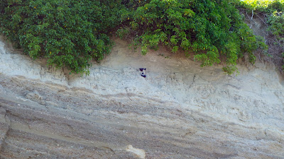
It’s interesting to note the dark stripe that runs horizontally, halfway up the bluff in both photos. This is the result of glacio-lacustrine deposits, sediment that settled in glacial meltwater during the Vashon glaciation period. More than 14,000 years ago, the Cordilleran glacial ice sheet, measuring at least 3000 feet deep, covered most of Western Washington. As it advanced and retreated, the glacier carved much of Puget Sound into the landforms and waterways we see today. It also left us with timeless features to match up in then and now photographs of our ever-eroding bluffs.

Port Williams bluff with two layers of sediment and 2 pigeon guillemots
A better look at the different sediment layers in the bluff, with bonus pigeon guillemots!

There are many other historic photographs of Port Williams to enjoy in the Bert Kellogg Collection, available for viewing on the Washington Rural Heritage digital archive website or in person at the Port Angeles branch of the North Olympic Library System.

4/29/20

The Red Lion Hotel on the Port Angeles Waterfront

Like many of the cities on the shoreline of the Salish Sea, downtown Port Angeles is built mostly on fill, and this fill material underlies one of the most most prominent buildings on the waterfront...the Red Lion Hotel.

Top photo:  Early 1900's photo from the Bert Kellogg collection, courtesy of the North Olympic Library System. Bottom photo: 2014 photo of the Red Lion Hotel on the Port Angeles waterfront. 
The historic photo above provides a sense for how dramatically that fill changed the coastal landscape, and how much the uses of the shoreline have changed.

Of special note in the historic perspective above is the wood cribbing used to buttress Front Street, still the main route into downtown from the east, and the small buildings on the beach.