Showing posts with label Duwamish people. Show all posts

12/23/22

The Black River Now and Then

 For 5,000 years the Black River was the southern outlet for Lake Washington flowing southwest into the Duwamish River. The Cedar River flowed into the Black River. 

The area was called "Inside Place". (LushootseedDxwdəw, from which comes the word "Duwamish"). Wikipedia Reference

Several Duwamish families had homes along the river for centuries and it was known as a strong fishery. 

As the settlers began to get settled the Cedar River which poured into the Black was diverted north into Lake Washington to prevent flooding. 


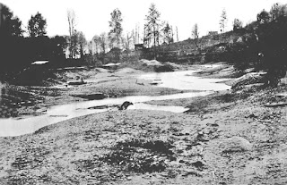
In 1916 as the Ship Canal and Ballard Locks were opened, Lake Washington dropped 9' thus drying out the source of the Black River, drying up most of the river.  


Years later, Boeing's Renton Plant and airfield plus additional development erased any remains of the river's source waters.  

Today, a small remnant of the river flows into the Duwamish and mostly ends in the Black River Riparian Forest within Renton's city limits.  

Aerial view of the area 1936:


2020 view:


Black River mouth into the Duwamish from the 
Green River Trail on Google Earth


I'll update this section with new photos once I get a window to get down there for the update the 4th edition of my book 'Kayaking Puget Sound and the San Juans' by Mountaineers Books. 


Read more in-depth details on the Black River from these sources:

Book: The River that Made Seattle, BJ Cummings

Book: Chief Seattle, David Buerge

Book: Native Seattle, Coll Thrush (includes list of village sites)

Seattle Map - 9 The Black River / David B. Williams

Book: Too High Too Steep - David's book on the Seattle regrade and other major land changes. 

Waterlines - Seattle Archeology

Wikipedia Black River

The Black River Disappears in 1916 - History Link

North Winds Weir on the Duwamish River

The North Wind Weir on the Duwamish River in Seattle is where the river ends it's channelized section and moves into it's un-straightened shoreline.  

The weir is a narrow section of the river where at low tide a rock shelf is exposed and further narrows the river channel and a class 1-2 river rapid.  

It was once a fishing area for the Duwamish people. Due to the rapid the saltwater mostly ends at the weir making it a interesting mix of salt and freshwater thus good for salmon fishing. As a paddler I've been interested in it as it's Seattle's only whitewater rapid.

It's located at 27th avenue south where the Green River Trail crosses the river.

Read about recent salmon conservation efforts at the weir.


The weir has a story that follows its history - (From Wikipedia):

According to Salish tradition, North Wind stretched a weir of ice across the Duwamish River at this site; no fish could pass, starving the people up the valley, the people of the Chinook Wind who was married to North Wind's daughter Mountain Beaver Woman. The mother of Mountain Beaver woman survived the starvation, but retreated to the mountain. Mountain Beaver Woman's son, the child Storm Wind, also survived.[2]

The people of the North Wind warned Storm Wind to stay away from the mountain, trying to keep from him the knowledge of what had happened to his people, but eventually he defied them and found his grandmother living in misery. He heard her story and helped her out of her misery; she, in return, aided him with a flood that shattered the weir and turned it to stone. Storm Wind and his grandmother defeated North Wind, who only occasionally and briefly torments the area with snow and ice. (From Wikipedia - Alan Stein (2000-08-15), "Arthur Ballard records and translates the legend of origin of the North Wind Weir on the Duwamish River beginning in 1916"HistoryLink, Seattle: History Ink, retrieved 2016-10-24)


Read the full story of the North Wind Weir from History Link


The weir is in the middle left 

1936 aerial view (weir middle left)


3/4/21

Duwamish River - A River with Big Change


The Duwamish River was straightened in 1913 after thousands of years as a natural flowing river whose tributaries originate below Mt Rainier.  

Home to the Duwamish people, Herring's House at the mouth to the now Elliott Bay had at least four longhouses and a huge potlatch house.  

Below is the Waterlines Project map sponsored by the Burke Museum.  The green dots are village sites. Blue are 'named places' or places of importance along the shoreline.  View the full map here

The below comparison is from the Duwamish River Clean-up Coalition page, view it here.


Read More about the Duwamish.. 

Native Seattle, Coll Thrush, UW Press

The River that Made Seattle, BJ Cummings, UW Press

Once and Future River, UW Press

Too High Too Steep, David Williams, UW Press

Chief Seattle, David Buerge, Sasquatch Books 


4/28/20

Looking up Salmon Bay to the Train Bridge and Locks - Now and Then

Here's another now and then view shot from about a block south of Salmon Bay Charlie's place, off 39th Ave W in Magnolia. 

The 1908 view shows why the name Shilshole means "threading the bread" in regards to getting a canoe or later a boat up past the mid-channel sand bars to upper Salmon Bay. 

Top Photo by: Wilse, Neg# 1165

The big sandbar on the Ballard side was titled CHutqeedud meaning "lying curled up" or "lying curled up like a pillow." It was known for great clamming.

As a paddler who loves to play in tidal rapids, this would've been a fun feature to have in the neighborhood. An opposing wind may of created standing waves to surf, or a fun rapid to run from upper Ballard to Shilshole Bay.  You can see some mini current generated river like waves in between the two sandbars. 

Unfortunately, all sandbars here were dredged to allow shipping through the Locks, built in 1916-1917. 

Look for posts in a few weeks showing views of this shoreline from the opposite perspective. 

Google Earth


Learn more about early Salmon Bay in following books:

Native Seattle - Coll Thush, UW Press

Waterway - The Story of Seattle's Locks and Ship Canal - Williams/Ott/HistoryLink

Also good info on the Duwamish and Shilshole people in this Wikipedia link


Post by Rob Casey
www.salmonbaypaddle.com