Showing posts with label Port Angeles. Show all posts

10/19/20

A look at a buried tide flat


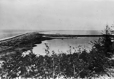
The photo above is another from Port Angeles, and is part of an extensive series of photos that appear to all have been taken as the downtown area was being filled in 1914.  Many of this series are part of the Bert Kellogg collection, hosted by the North Olympic Library, but this particular photo doesn't appear to be available in that collection.  I obtained this photo from Dr. Karl Wegmann, who had collected a large set of historic photos of Port Angeles to support a report to the City of Port Angeles, and a subsequent paper.  

This particular photo was taken right about here, and the view from the same perspective looks considerably different today:

16 October 2020 photo taken looking southeast from the corner of Railroad and Laurel in downtown Port Angeles, Washington.

I like this particular historic photo because you can make out the intertidal flats that would have fringed Port Angeles harbor historically.  From the looks of it I'm guessing that it was prime habitat for clams, birds and fish, and it would have been quite cool to check out.  Its still there of course, but buried under many feet of fill...

7/6/20

Ediz Hook Part Four: The Light House

I think this will be the last one for a bit on Ediz Hook...time to move on to other large spits!  But for number 4 I wanted to stick with the old stately lighthouse that used to grace the end of Ediz Hook...an area that has now evolved into a sort of storage lot for the USCG base that now takes up the end of the Hook.  Here is an 1890 photo of one of the first Ediz Hook lighthouse (there was another built in the early 1900's):
Ediz Hook lighthouse, 1890.  Photo from the Bert Kellogg collection, hosted by the North Olympic Library System
So this photo is a bit hard to place exactly, given that you can't make out any landmarks in the photo.  However, if my placement of the fog bell that I covered in this previous blog is correct, then this is roughly the modern perspective of the 1890 shot above:
9 June 2020 photo of Ediz Hook.  Photo by Ian Miller
Again, impressive changes to this impressive place on Washington's shoreline.  BTW this original Ediz Hook lighthouse (or perhaps one of the later buildings?) apparently still exists as a house in Port Angeles.  One of my earliest Coastnerd Gazette entries attempted to tell the story...

6/25/20

Ediz Hook Part Three: The Fog Bell

I'm just going to continue on with a focus on changes to Ediz Hook, and notably the beautiful old lighthouse facility that used to sit on its tip.  Part 1 and Part 2 are here and here.  Below is a 1907 view of the fog bell that once sat on the end of Ediz Hook:

1907 photo of fog bell on the end of Ediz Hook.  Photo from the Burt Kellogg collection, hosted by the North Olympic Library System.
This view is notable for a variety of reasons.  One, it was shot in winter, and there is snow on the ground.  Second, it appears that this was a manual bell...so during foggy weather, or presumably any time visibility was impaired, the light-keeper had to be working that bell.  Pretty astonishing.

I could find no trace of this building...no foundation, no indentation in the grass.  However, based on the outline of the mountains that are visible behind the building its evident that this photos was taken from roughly here, looking towards the south.  Here is the modern view, as close as I felt I could match it:

Photo collected 9 June 2020, Ediz Hook, by Ian Miller
The site of this fog bell building is important, as it is the only thing that provides any reference for a few other photos of the lighthouse complex that sat on Ediz Hook.  A post to follow will focus on one of those photos.

6/17/20

Ediz Hook Part Two - From the Other End

Every year I try to make it out the the end of Ediz Hook to collect survey data to add to a multi-year monitoring study of beaches in Washington State.  Since the whole of the end of the Hook is part of a US Coast Guard base, its not just a simple matter of driving out there...it takes a bit of set up.  But its always fun and interesting.  My trip out there this year was last week, and I figured it also offered a stellar opportunity to provide some perspective on changes to the Hook to complement my earlier post on Ediz Hook.  Notably, the end of Ediz Hook used to host a lighthouse, built in 1865 and subsequently modified a few times.  For this post I want to focus on this photo, dated to the 1880's and presumably shot from the lighthouse tower, looking landward along the Hook:

Photo taken in the 1880's looking landward along Ediz Hook.  From the Burt Kellogg collection, hosted by the North Olympic Library System.  
There really isn't much trace of the lighthouse or its associated buildings out at the end of Ediz Hook anymore, but there are a few more modern storage buildings...and one of them has a flight of stairs that allowed me to get up pretty close to where this photo was shot ~140 years ago.  Here is what the view looks like now:

Photo by Ian Miller, collected 9 June 2020
Ediz Hook is so heavily modified...you have to really use your imagination to get a sense for what an amazing habitat it must have been.  I would love to be able to go back to when the 1880's photo above was shot and take a look around.

6/6/20

Elwha River Dike and Fox Point Bunker

Here's stories from the Evening News and Chronicle from 1962 and 1963 detailing interest in building a dike to control the flow of the Elwha River to save Place Road homes from being affected by high water flooding.  

A former WW2 fire control bunker at the end of Fox Point had fallen into the river sometime before the article as a result of erosion. 

I included a Puget Sound Harbor Defense document showing the location of the former WW2 bunker. The bunker would've been the same simple pillbox style also seen near the camping area at Camp Hayden / Salt Creek Rec Area.  

There's been recent interest from the Coastal Watershed Institute in PA to remove part of the dike to help restore the original river flow and help save struggling salmon runs. The last I heard, the Place Road neighbors had met with CWI discuss their interests.  The effect of Covid-19 on things have slowed progress on this project.  

From the Chronicle, written by Del Price.

From the Chronicle, written by Del Price.


5/21/20

The Transformation of Urban Shorelines: Port Angeles

Most shorelines of urban coastal communities in Washington have been radically transformed by fill, and Port Angeles is no different.  Downtown Port Angeles was originally built essentially right on the beach:

View looking west from the bluffs just to the east of downtown Port Angeles.  Unknown date, but presumably prior to 1914.  Photo from the Burt Kellogg Collection, available through the North Olympic Library System
The contemporary view highlights the changes to the shoreline, most of which were brought about by a massive 1914 filling project:

Contemporary view of downtown Port Angeles, looking west from the bluff just to the east of downtown.  The Red Lion hotel is prominent in the foreground, and Ediz Hook is visible in far field.  Photo collected 4 March 2014 by Ian Miller. 

5/11/20

Something a bit different...restoration on the shoreline

The fundamental idea behind this blog was to provide modern perspectives of Washington's historic shorelines, and highlight the transformations that Washington's shorelines have gone through over the last 100 to 150 years.  I've decided to do something a bit different with this post though, and focus it on radical change to Washington's shoreline associated with a restoration.  I've been incredibly fortunate to be part of the community of scientists focused on studying the effects associated with the removal of the Elwha River dams.  In particular I've been interested in the coastal influences, both physical and ecological.  Through that work, I've revisited spots on the Elwha River delta repeatedly for well over a decade, including this spot right here. Back in 2011, the view from this spot looked like this:

Photo taken looking up the beach during low tide, on 2 August 2011.  Photo originally published at https://coastnerd.blogspot.com/2018/06/elwha-update.html 
Just a handful of years later, after dam removal transformed the coastal landscape near the river mouth, the view from that exact spot is radically different:

June 2018 photo looking south from what used to be the beach.  Photo originally published at https://coastnerd.blogspot.com/2018/06/elwha-update.html 

5/6/20

Ediz Hook

No trip down the memory lane of Washington's shorelines would be complete without a stop in to consider Ediz Hook.  Ediz Hook is a roughly 3.5 mile long "recurved" spit extending into the Central Strait of Juan de Fuca, the embayment of which forms Port Angeles Harbor.  Ediz Hook hosts a pulp and paper mill, a road, a boat ramp, the Puget Sound Pilot's boat station, and a large US Coast Guard facility.  Not surprisingly, Ediz Hook has been heavily modified over time, and looks considerably different today than it did at the turn of the 20th century.  This view of Ediz Hook (taken from somewhere near modern Crown Park), for example, dates to 1884:

1884 view of Ediz Hook.  Photo is part of the Washington Rural Heritage collection, accessed via the North Olympic Library System.
And here is the modern view from the same perspective:

Photo collected by Ian Miller 19 February 2014
Prominent in the modern view is the pulp and paper mill, first built around 1920.  Harder to see from this vantage are the many other modifications that have turned Ediz Hook from the natural sand spit it was in 1884 into something that many take to be a man-made harbor defense works.  Here is the view down on the beach near the mill, for example:

10 February 2017 photo taken looking west from a point just to the east of the mill shown in the photo above.  Photo collected by Ian Miller
showing the large rock, placed to protect Ediz Hook from erosion, that is now a prominent feature of the Ediz Hook shoreline.

4/29/20

The Red Lion Hotel on the Port Angeles Waterfront

Like many of the cities on the shoreline of the Salish Sea, downtown Port Angeles is built mostly on fill, and this fill material underlies one of the most most prominent buildings on the waterfront...the Red Lion Hotel.

Top photo:  Early 1900's photo from the Bert Kellogg collection, courtesy of the North Olympic Library System. Bottom photo: 2014 photo of the Red Lion Hotel on the Port Angeles waterfront. 
The historic photo above provides a sense for how dramatically that fill changed the coastal landscape, and how much the uses of the shoreline have changed.

Of special note in the historic perspective above is the wood cribbing used to buttress Front Street, still the main route into downtown from the east, and the small buildings on the beach.