Showing posts with label Seattle history. Show all posts

12/23/22

The Black River Now and Then

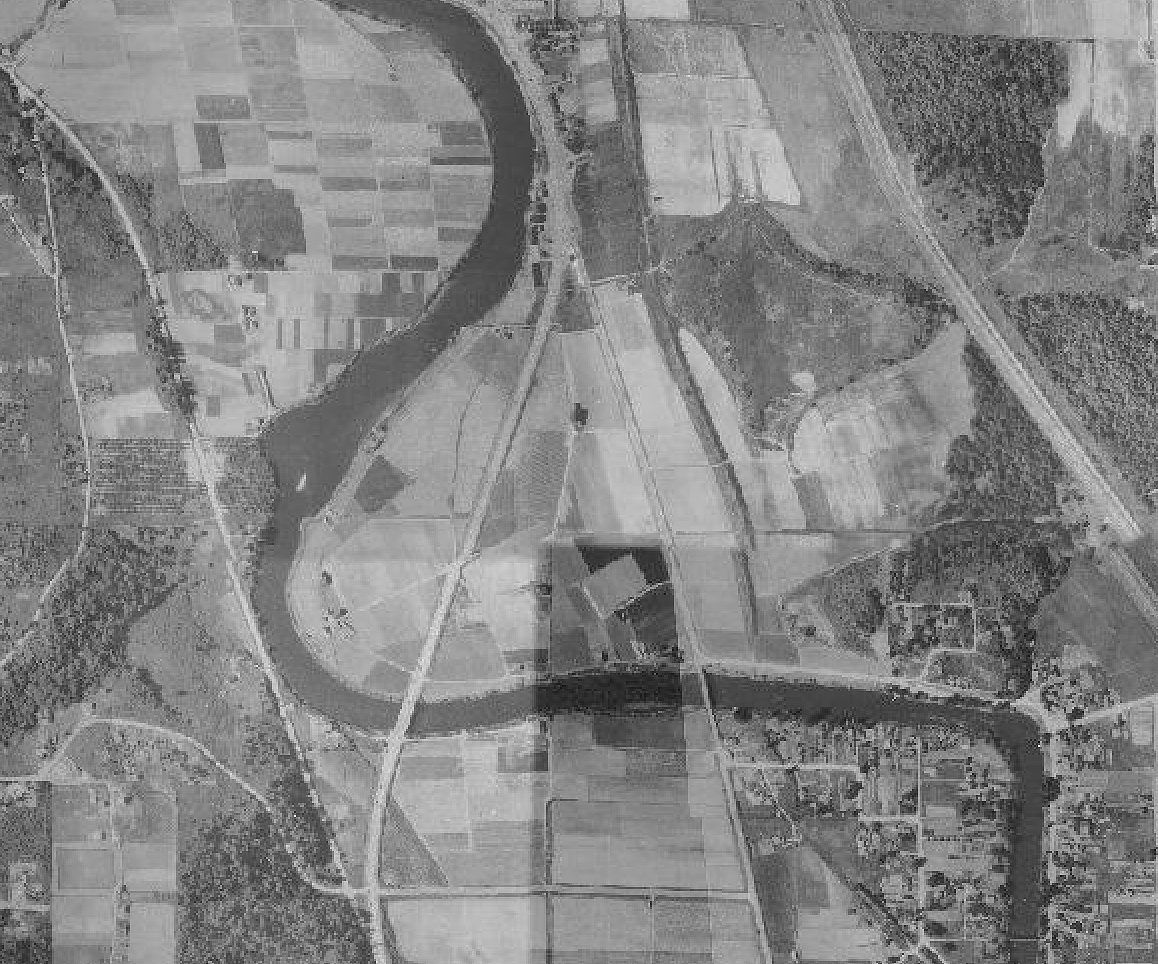
 For 5,000 years the Black River was the southern outlet for Lake Washington flowing southwest into the Duwamish River. The Cedar River flowed into the Black River. 

The area was called "Inside Place". (LushootseedDxwdəw, from which comes the word "Duwamish"). Wikipedia Reference

Several Duwamish families had homes along the river for centuries and it was known as a strong fishery. 

As the settlers began to get settled the Cedar River which poured into the Black was diverted north into Lake Washington to prevent flooding. 


In 1916 as the Ship Canal and Ballard Locks were opened, Lake Washington dropped 9' thus drying out the source of the Black River, drying up most of the river.  


Years later, Boeing's Renton Plant and airfield plus additional development erased any remains of the river's source waters.  

Today, a small remnant of the river flows into the Duwamish and mostly ends in the Black River Riparian Forest within Renton's city limits.  

Aerial view of the area 1936:
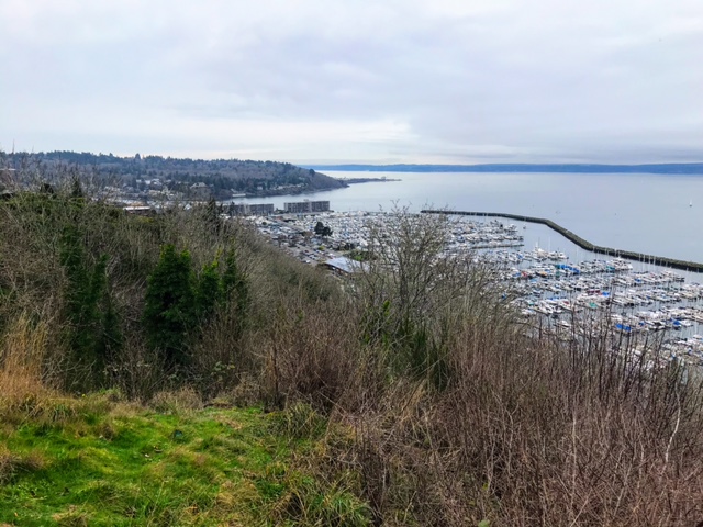

2020 view:


Black River mouth into the Duwamish from the 
Green River Trail on Google Earth


I'll update this section with new photos once I get a window to get down there for the update the 4th edition of my book 'Kayaking Puget Sound and the San Juans' by Mountaineers Books. 


Read more in-depth details on the Black River from these sources:

Book: The River that Made Seattle, BJ Cummings

Book: Chief Seattle, David Buerge

Book: Native Seattle, Coll Thrush (includes list of village sites)

Seattle Map - 9 The Black River / David B. Williams

Book: Too High Too Steep - David's book on the Seattle regrade and other major land changes. 

Waterlines - Seattle Archeology

Wikipedia Black River

The Black River Disappears in 1916 - History Link

The Lake Washington Shipyard Now and Then

Opened in the 1870's as a small boat builder called Anderson Shipyard, the Lake Washington Shipyard began it's legacy as a maritime center building early ferries and other craft.  

Anderson Shipyard, 1900

The boatyard is located in Houghton near Kirkland, WA. 

When the Locks were built the lake was lowered 9 feet but the shipyard adjusted it's docks knowing access to the Sound would bring more business. 

Photo from Northwest Legacy (Jeremy Snapp)


During the late 1930's the Mosquito Fleet were kept at the shipyard with an uncertain future. The Mosquito Fleet which includes the Virginia 5 was once the main way to move people around Puget Sound.

Photo from Northwest Legacy (Jeremy Snapp)


In World War 2 the shipyard built several vessels to support the war.  See the list on Wikipedia

In 1947 the shipyard was purchased and in 1960 it was closed.  Today the former shipyards are now Carillon Point, a residential and commercial area with a marina.  

Read more on the History Link 


1936 Aerial view


The Mosquito Fleet images copied from the Northwest Legacy, Sail, Steam and Motorships, by Jeremy Snapp


North Winds Weir on the Duwamish River

The North Wind Weir on the Duwamish River in Seattle is where the river ends it's channelized section and moves into it's un-straightened shoreline.  

The weir is a narrow section of the river where at low tide a rock shelf is exposed and further narrows the river channel and a class 1-2 river rapid.  

It was once a fishing area for the Duwamish people. Due to the rapid the saltwater mostly ends at the weir making it a interesting mix of salt and freshwater thus good for salmon fishing. As a paddler I've been interested in it as it's Seattle's only whitewater rapid.

It's located at 27th avenue south where the Green River Trail crosses the river.

Read about recent salmon conservation efforts at the weir.


The weir has a story that follows its history - (From Wikipedia):

According to Salish tradition, North Wind stretched a weir of ice across the Duwamish River at this site; no fish could pass, starving the people up the valley, the people of the Chinook Wind who was married to North Wind's daughter Mountain Beaver Woman. The mother of Mountain Beaver woman survived the starvation, but retreated to the mountain. Mountain Beaver Woman's son, the child Storm Wind, also survived.[2]

The people of the North Wind warned Storm Wind to stay away from the mountain, trying to keep from him the knowledge of what had happened to his people, but eventually he defied them and found his grandmother living in misery. He heard her story and helped her out of her misery; she, in return, aided him with a flood that shattered the weir and turned it to stone. Storm Wind and his grandmother defeated North Wind, who only occasionally and briefly torments the area with snow and ice. (From Wikipedia - Alan Stein (2000-08-15), "Arthur Ballard records and translates the legend of origin of the North Wind Weir on the Duwamish River beginning in 1916"HistoryLink, Seattle: History Ink, retrieved 2016-10-24)


Read the full story of the North Wind Weir from History Link


The weir is in the middle left 

1936 aerial view (weir middle left)


11/14/22

Tillicum towing Kitsap out of Ballard, 1916

 I spend a lot of time paddling and walking the shorelines of Seattle's Salmon and Shilshole Bays and thinking about now and then perspectives.  

While browsing the Seattle Public Library Special Collections online last night I came across these images I've never seen before titled - Tillicum towing Kitsap out of Ballard, 1916 (spl_shp_40570)

And just behind the Kitsap is a dredger probably working to clear a channel below the newly constructed Ballard Locks just upstream.  

The image is shot from Magnolia looking NE towards Ballard and Sunset Hill. 


For me, there's a lot going on in these image. It's not just a majestic ship being towed out of Salmon Bay but I wonder if the foreground is Salmon Bay Charlie's (Hwehlchtid) land protruding into the channel before it was dredged?  


In the horizontal image the train bridge at NW 61st St is a bit further down to right suggesting that this could be Charlie's later dredged spot.  

Comparing a popular image of his place (below), the large cleanly cut beach log in the foreground looks familiar.  But this image is in 1905 and the Kitsap images (above) are 1916. The above images face the opposite direction.  

1905, Webster and Stevens Studio, UW Libraries.

I've been researching the Ballard shoreline where I spend a lot of time in the Elks Lodge and adjacent beach as an Elks Member and for my paddling business, Salmon Bay Paddle. The Elks Lodge would be built in the 1960's in the space between the dredger and the Kitsap.  

And further in the distance on the hill above the now Golden Gardens Park is a full growth of probably old growth trees, unlike the scene further to the south or (right) which was mostly logged in the 1870's. 


4/14/22

"Seattle Waterfront. 1882-1886. Canoes and Indians in Belltown. Foot of Vine St. Cedar and Broad St. Photo by Asahel Curtis."

 From the Seattle Public Library Special Collections, a 1882 view of the Seattle waterfront at the approx base of Vine St. Cedar and Broad Streets by Asahel Curtis. (View in Collections)  Looking northeast.


Here's the approx 2021 view of the bottom of Vine Street from Google Earth looking NE.  The 1882 image and shoreline would've been around the location of the railroad tracks. The Seattle waterfront was extended out quite a bit beyond the original shoreline. 


Seattle’s waterfront (below), viewed from Bell Street in 1930.
 Courtesy of the Seattle Municipal Archives, item No. 4101. The 1882 view above would've been on the lower left below the hill in the image here, (Looking South)


3/4/21

Duwamish River - A River with Big Change


The Duwamish River was straightened in 1913 after thousands of years as a natural flowing river whose tributaries originate below Mt Rainier.  

Home to the Duwamish people, Herring's House at the mouth to the now Elliott Bay had at least four longhouses and a huge potlatch house.  

Below is the Waterlines Project map sponsored by the Burke Museum.  The green dots are village sites. Blue are 'named places' or places of importance along the shoreline.  View the full map here

The below comparison is from the Duwamish River Clean-up Coalition page, view it here.


Read More about the Duwamish.. 

Native Seattle, Coll Thrush, UW Press

The River that Made Seattle, BJ Cummings, UW Press

Once and Future River, UW Press

Too High Too Steep, David Williams, UW Press

Chief Seattle, David Buerge, Sasquatch Books 


2/1/21

Seattle's Ballard Beach Pre-Shilshole Marina and Present Day

Seattle experienced big changes along it's shorelines in the 20th century.  In Ballard, Shishole Bay went from a rural gravel covered beach with forested hillsides to fully developed with filled in shores, pavement and residential areas.  

Ballard Beach pre-road (looking North to Golden Gardens)


Ballard Beach, 1920's looking South


Burke Gilman link, Seaview Ave and Shilshole Marina, 2021


Ballard Beach looking southwest towards the entry to Salmon Bay, Magnolia and West Point


From 34th NW street overlooking Shilshole Marina, approx 1960's, early marina days.


                               From the 34th NW St park overlooking Shilshole Marina 2021

1/31/21

Seattle's West Point Lighthouse - 1940 and 2021

I came across this 1940 photo in one of the Magnolia Historical Society's books 'Magnolia Memories'.  

What's significant about it is that it's before the sanitation facility was installed in the 1960's. 

History Link states "This low sand spit, made by the opposing currents on the sound, was known to the Duwamish Indians by "Per-co-dus-chule," or "Pka-dzEltcua," which translates "thrusts far out." It was known to early mariners as Sandy Point."  If you have flash, this is a great history of West Point link.

The shoreline is untouched on the south and north sides and the point aside from the 1881 era lighthouse depicts the other low points with a salt marsh seen elsewhere around the Sound such as Marrowstone Point. 

Lighthouse Friends points out that Seattle's raw sewage poured out onto the seemingly pristine beaches making for quite a stink. 

The young man in the photo probably didn't know what was coming his way with WW2 starting in the US later the next year.   

As a paddle surfer, I like the boat wakes in the lower left image probably by the boat that just passed the point upper right.  These days we surf small and freighter size surf along West Point.  


The now image isn't as exciting. Bluff erosion and heavy foliage kept me from being more to the left as the before image depicts.  I shot the image in January for better visibility through the trees.  

There's a path with a wooden railing leading to the view from the main road.  


Google Earth cropped view from (5/26/2018).  North -->

Posted by Rob Casey, 1/21


8/24/20

Ballard Shoreline Aerial Comparisons - 1940 and 2020

 Here's a fun comparison of the 1940's Ballard / Seattle shoreline and the current view from Google Earth.  

The now view is of the Seaview Avenue shoreline at the entry to Salmon Bay and Shilshole Bay at the location of the now Ray's Boathouse, former Anthony's, Ballard Elks Club, Sunset West Condos and the south corner of Shilshole Bay Marina.  

The bit of land across the channel is the NE corner of the Magnolia neighborhood.  

The 1940 view shows a different less developed shoreline with the reindeer ship, the SS Bering beached in front of the now Elks Club.  In the 1940's, the Tregoning Boat Company was located there.  

I believe the Ballard ferry landing was just south of (or above here) of Ray's Boathouse (to Port Ludlow and Suquamish).

The older photo also shows more beach homes across from Seaview Ave. Only a few are left now along with a few condos and misc buildings.  

From a surfing perspective, Point Shilshole is the point of land jutting out in the older photo. There's a nice wind swell rolling in and whitewater just offshore and along the shore.  

Looks like a good surf spot. We surf freighter and wind waves on Shilshole Bay so without the extra development and marina, we'd have one more downwinding and shore break spot!


Below is a Now and Then view from the Ballard Elks Lodge with the SS Bering looking out into Shilshole Bay. The ship was burned to make way for development in the early 1960'.  Now view from the Ballard Elks Sunset Cam.


8/8/20

Ballard Boat Works 1905 and Present

Sivert Engelsen Sagstad, a young Norwegian boat builder emigrated to Seattle and opened Ballard Boat Works, pictured here on lower Salmon Bay, pre-Locks in 1905.

I paddle past this shoreline weekly and have been trying to look for any early evidence of his boatyard and as well as any Shilshole tribal evidence which was prevalent along the shoreline prior to the boatyard.

When the Ballard Locks were being developed some of the shoreline below the boatyard was removed. In the 1905 mage, note that the shoreline had a gentle slope to the water.  In the Now images, the shoreline is shorter and abruptly drops to the water. 

Read more about Sagstad and the 70' Viking ship replica in this article from HistoryLink..  Read the HistoryLink story 

Now view from Seaview Picnic Park

Ballard Boat Works in 1905 and 'Now' view from Seaview Picnic Park

'Now' view from Seaview Picnic Park (location of yellow arrow)

2020 view of approx Ballard Boat Works location.  Photo: Salmon Bay Paddle


4/28/20

Looking up Salmon Bay to the Train Bridge and Locks - Now and Then

Here's another now and then view shot from about a block south of Salmon Bay Charlie's place, off 39th Ave W in Magnolia. 

The 1908 view shows why the name Shilshole means "threading the bread" in regards to getting a canoe or later a boat up past the mid-channel sand bars to upper Salmon Bay. 

Top Photo by: Wilse, Neg# 1165

The big sandbar on the Ballard side was titled CHutqeedud meaning "lying curled up" or "lying curled up like a pillow." It was known for great clamming.

As a paddler who loves to play in tidal rapids, this would've been a fun feature to have in the neighborhood. An opposing wind may of created standing waves to surf, or a fun rapid to run from upper Ballard to Shilshole Bay.  You can see some mini current generated river like waves in between the two sandbars. 

Unfortunately, all sandbars here were dredged to allow shipping through the Locks, built in 1916-1917. 

Look for posts in a few weeks showing views of this shoreline from the opposite perspective. 

Google Earth


Learn more about early Salmon Bay in following books:

Native Seattle - Coll Thush, UW Press

Waterway - The Story of Seattle's Locks and Ship Canal - Williams/Ott/HistoryLink

Also good info on the Duwamish and Shilshole people in this Wikipedia link


Post by Rob Casey
www.salmonbaypaddle.com

Salmon Bay Charlie's Home in Seattle

1905 view of Hwelchteed and Cheethlooleetsa's home on the NE point of Magnola, across from Ballard.  Photo by Webster and Stevens. 

The view looks up (SE) Salmon Bay towards the narrow bottleneck where the Ballard Locks and bascule train bridge were built between in 1915-1917. 


Hwelchteed was also known as Salmon Bay Charlie, the last chief of the Shilshole people who once had several longhouses inside the what is now Ballard and the Locks. 

The village was called 'Tucked Away Inside' for its hidden protected view from the Sound.  

Hwelchteed was evicted from his home in 1913 to make way for the Ballard Locks. The little point his house was perched on was removed as were sandbars across the channel. 

The taller of the two trees is often spotted in other photos of the bay during this period. 

See shoreline change in this photo.  Paddling past at lower tides you can see where the shoreline was dredged into a deeper channel. The shoreline only has one non-armored section just beyond where the photo is.  


His home was located near W Sheridian Street. 


Read more about this area in Coll Thrush's book Native Seattle.  

Also check Paul Dorpat's Seattle Times article on Salmon Bay. Lots of 19th century photos and maps.


Posted by Rob Casey