Showing posts with label Ballard. Show all posts

11/14/22

Tillicum towing Kitsap out of Ballard, 1916

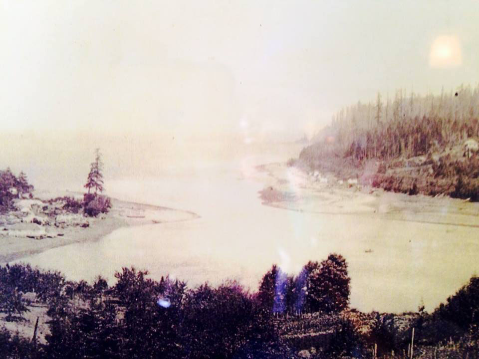
 I spend a lot of time paddling and walking the shorelines of Seattle's Salmon and Shilshole Bays and thinking about now and then perspectives.  

While browsing the Seattle Public Library Special Collections online last night I came across these images I've never seen before titled - Tillicum towing Kitsap out of Ballard, 1916 (spl_shp_40570)

And just behind the Kitsap is a dredger probably working to clear a channel below the newly constructed Ballard Locks just upstream.  

The image is shot from Magnolia looking NE towards Ballard and Sunset Hill. 


For me, there's a lot going on in these image. It's not just a majestic ship being towed out of Salmon Bay but I wonder if the foreground is Salmon Bay Charlie's (Hwehlchtid) land protruding into the channel before it was dredged?  


In the horizontal image the train bridge at NW 61st St is a bit further down to right suggesting that this could be Charlie's later dredged spot.  

Comparing a popular image of his place (below), the large cleanly cut beach log in the foreground looks familiar.  But this image is in 1905 and the Kitsap images (above) are 1916. The above images face the opposite direction.  

1905, Webster and Stevens Studio, UW Libraries.

I've been researching the Ballard shoreline where I spend a lot of time in the Elks Lodge and adjacent beach as an Elks Member and for my paddling business, Salmon Bay Paddle. The Elks Lodge would be built in the 1960's in the space between the dredger and the Kitsap.  

And further in the distance on the hill above the now Golden Gardens Park is a full growth of probably old growth trees, unlike the scene further to the south or (right) which was mostly logged in the 1870's. 


3/30/22

Salmon Bay Entry Before and After Ballard Locks Dredging

Here's two glimpses of images showing Seattle's Salmon Bay's entry into Shilshole Bay before the Chittenden (or Ballard) Locks dredging and the current view.  

The Shilshole people called the mouth of Shilshole 'sHulsHOOLOOTSeed'

Originally the channel had a few sandbars stretching across and was wade-able at low tide.  Shilshole means 'like shoving a thread through a bead.'  

Before dredging, a large sandbar existed (seen here) on top right on the Ballard side just south of Ray's Boat house, called 'Hanging on the Shoulder' or KeehLalabud.'  The sandbar was known for good clamming. Photo: MOHAI. 

Dredging for the Locks occurred around 1915 ish.  

Photo by Wilse

The March 2022 photo below shows my surf ski parked on the Ballard side below Seaview Ave.  The tide is a touch higher than the older photo but in either case dredged sandbar would've been visible.  


As 'settlers' arrived and built logging mills upstream in downtown Ballard, boats could only enter or exit at high tide.  

The image above shows tall masted ships moored in Shilshole Bay probably waiting for the tide and their turn to enter the narrow mouth.  

Here's an 1890's view from Magnolia looking North towards the Salmon Bay 
entry into Shilshole Bay


Here's a 'Washington Territory' pre-Locks chart of the same area showing sand bars and undeveloped shoreline of Salmon and Shilshole Bays. 


Sources and Resources:

The above native terms were taken from Coll Thrush's 'Native Seattle' book by UW Press.  

Read also Paul Dorpat's post on this spot Here

And David William's book 'Waterway' on the history of Seattle's Ship Canal.


2/1/21

Seattle's Ballard Beach Pre-Shilshole Marina and Present Day

Seattle experienced big changes along it's shorelines in the 20th century.  In Ballard, Shishole Bay went from a rural gravel covered beach with forested hillsides to fully developed with filled in shores, pavement and residential areas.  

Ballard Beach pre-road (looking North to Golden Gardens)


Ballard Beach, 1920's looking South


Burke Gilman link, Seaview Ave and Shilshole Marina, 2021


Ballard Beach looking southwest towards the entry to Salmon Bay, Magnolia and West Point


From 34th NW street overlooking Shilshole Marina, approx 1960's, early marina days.


                               From the 34th NW St park overlooking Shilshole Marina 2021