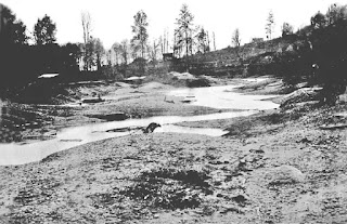
For 5,000 years the Black River was the southern outlet for Lake Washington flowing southwest into the Duwamish River. The Cedar River flowed into the Black River.
The area was called "Inside Place". (Lushootseed: Dxwdəw, from which comes the word "Duwamish"). Wikipedia Reference
Several Duwamish families had homes along the river for centuries and it was known as a strong fishery.
As the settlers began to get settled the Cedar River which poured into the Black was diverted north into Lake Washington to prevent flooding.
In 1916 as the Ship Canal and Ballard Locks were opened, Lake Washington dropped 9' thus drying out the source of the Black River, drying up most of the river.
Years later, Boeing's Renton Plant and airfield plus additional development erased any remains of the river's source waters.
Today, a small remnant of the river flows into the Duwamish and mostly ends in the Black River Riparian Forest within Renton's city limits.
Aerial view of the area 1936:
2020 view:
I'll update this section with new photos once I get a window to get down there for the update the 4th edition of my book 'Kayaking Puget Sound and the San Juans' by Mountaineers Books.
Read more in-depth details on the Black River from these sources:
Book: The River that Made Seattle, BJ Cummings
Book: Chief Seattle, David Buerge
Book: Native Seattle, Coll Thrush (includes list of village sites)
Seattle Map - 9 The Black River / David B. Williams
Book: Too High Too Steep - David's book on the Seattle regrade and other major land changes.
Waterlines - Seattle Archeology
The Black River Disappears in 1916 - History Link


.jpg)


