Showing posts with label Puget Sound. Show all posts

2/25/22

When it was Cool to Burn Ships on Puget Sound..

As the maritime industry moved away from wood and more into steel hulls, the older boats were discarded, grounded or burned.  

On Puget Sound, it became a common practice to burn the old ships from the 1920's to the 1950's.  At low tides, scrap metal would be recovered. 

Families would come out and set up a picnic while watching ships burn along the shore at Richmond Beach and other spots along the Sound.  

Assuming this was before the environmental movement.  

Here's one from Richmond Beach titled by MOHAI as "Burning hull of the steam tug "Daniel Kern," April 1939". Read more about the Kern here


Read more about the Richmond Beach burning events at this link, called the Ronald BlogClick Here


Here's a Google Maps view of the beach north of Picnic Point where a few were burned or grounded. 


The SS Bering, a former reindeer ship was bought by the Tregoning Boat Company in Ballard (Seattle) and was beached at what is now called Secret Beach.  

In 1964 it was burned to make way for shore development such as the Ballard Elks Lodge.  I wrote about the SS Bering in this blog post from 2000.  

Older Elks members told me they played on the ship as kids, one jumping off of it into the water.    At low tide you can still find burned pieces of wood with bolts and nails on the beach there. 


Current View at a -1 tide...


11/3/21

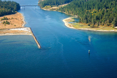
From Craven Peninsula to Port Townsend Canal

 In 1841 explorer Charles Wilkes named the small stretch of gravel connecting Port Hadlock with Indian Island Craven Peninsula after a member of his crew, Lt Charles Craven.

The peninsula was submerged at high tides. Natives and later settlers portaged over the peninsula at high tides.  

As early as the mid 1800's, there was interest in dredging the peninsula to make the channel a channel for shipping.  

Finally in 1915, the peninsula was dredged and a canal was created.  Local residents were promised a bridge that didn't come until 1952.  Prior, residents and later the Navy on Indian Island used a variety of boats and later ferries to cross the channel.  

Read more about the story of Craven Peninsula, the dredging, ferries and the bridge on this link:

Peninsula Daily News


1/31/21

Seattle's West Point Lighthouse - 1940 and 2021

I came across this 1940 photo in one of the Magnolia Historical Society's books 'Magnolia Memories'.  

What's significant about it is that it's before the sanitation facility was installed in the 1960's. 

History Link states "This low sand spit, made by the opposing currents on the sound, was known to the Duwamish Indians by "Per-co-dus-chule," or "Pka-dzEltcua," which translates "thrusts far out." It was known to early mariners as Sandy Point."  If you have flash, this is a great history of West Point link.

The shoreline is untouched on the south and north sides and the point aside from the 1881 era lighthouse depicts the other low points with a salt marsh seen elsewhere around the Sound such as Marrowstone Point. 

Lighthouse Friends points out that Seattle's raw sewage poured out onto the seemingly pristine beaches making for quite a stink. 

The young man in the photo probably didn't know what was coming his way with WW2 starting in the US later the next year.   

As a paddle surfer, I like the boat wakes in the lower left image probably by the boat that just passed the point upper right.  These days we surf small and freighter size surf along West Point.  


The now image isn't as exciting. Bluff erosion and heavy foliage kept me from being more to the left as the before image depicts.  I shot the image in January for better visibility through the trees.  

There's a path with a wooden railing leading to the view from the main road.  


Google Earth cropped view from (5/26/2018).  North -->

Posted by Rob Casey, 1/21


11/13/20

Landing craft on the beach at Fort Worden

 A quick post today from Fort Worden in Port Townsend. I mostly want to use this post to amplify the great work by Fort Worden historian Tim Caldwell with his regular column in the Port Townsend Leader newspaper. Kudos to the newspaper and the community for continuing to celebrate and share the story of this special place. 

Tim shared this same historical photo of landing craft on the beach at Point Wilson earlier this year. Please enjoy Tim's history behind this photo at the Port Townsend Leader's website and enjoy my now photo here for comparison:

Point Wilson at Fort Worden Then (1950) and Now (2020)
(Historical photo courtesy of the Jefferson County Historical Society)

In the distance you see the Point Wilson lighthouse, which has stood since 1879, although it was rebuilt in 1914. It was built on a very sandy beach and the shoreline to the north was heavily armored in an effort to protect the lighthouse and associated buildings from the large wind waves from the Strait of Juan de Fuca that pummel the beach and threatened the integrity of these structures. The negative effects of shoreline armoring obviously weren't known in those days. 

Please visit this page from the National Archives to see photos of the previous lighthouse and the beach before the riprap was placed. For more information about the history of the lighthouse, please visit lighthousefriends.com, and for current information please visit pointwilsonlighthouse.org


:


10/9/20

Flagler's guns come ashore at Marrowstone Point

My favorite place to visit here on the Olympic Peninsula is Fort Flagler on Marrowstone Island. The former coast artillery fort is now a state park offering the best views of Puget Sound you can hope to find, including powerful currents and marine wildlife to watch, historical military structures to explore, and let’s toss in a lighthouse (well, sort of) for good measure. All these features make it an endlessly entertaining place to visit for a day, a weekend, or longer.

The historical photo for today’s blog post really blew my mind when I first saw it. It's a shot of Marrowstone Point from 1898, when Fort Flagler was under construction. I hope you enjoy my now photo, but you really should go to Jefferson County Historical Society’s site and look at the original historical photo. There are so many fascinating details to spot. Those are enormous cannon barrels being brought ashore from a barge on the beach. And in the distance on the left is the Marrowstone Light Station keeper's residence.

Marrowstone Point at Fort Flagler in 1898 and 2020
(Historical photo courtesy of Jefferson County Historical Society

Construction of Fort Flagler began in 1897 but the U.S. government was active here a decade earlier in the interest of maritime safety. A light to guide mariners has shone at Marrowstone Point in one form or another since 1888, but not from the traditional lighthouse tower that most of us would think of. Starting with a lens lantern mounted on a pole, the light eventually was erected atop a 20 ft. concrete building where it has been located since 1918. 

The light keeper's residence in both our now and then photos has acted as sentinel, standing at the shoreline since 1896. Just offshore, Puget Sound's unwieldy winds and dense fog can make navigating the strong currents rushing through narrow Admiralty Inlet a harrowing experience for vessels of any size. One calamitous event happened here in 1892 when the freighter S.S. Willamette rammed the S.S. Premier at full speed, killing five and injuring 18. Although neither ship sank, the damage to the Premier was significant to say the least. Take a look for yourself.  😮

The light still shines, now automated, but since the mid-1970s the site and structures have primarily served federal scientific research as the U.S. Geological Survey’s Marrowstone Marine Field Station. Their current work is focused on fish and overall marine ecosystem health. The light keeper's residence provides lodging for visiting scientists.

Marrowstone Point 1895 map
(National Archives)

I have not been able to track down information on the barn or other buildings we see in the historical photo. But on a map of the fort from 1913, the buildings are labeled as “old stables” and “old laundry.” Structures also appear on a map from 1895, but have no information. If anyone knows more, please share.

Fort Flagler 1913 map
(National Archives)

In addition to these maps, the National Archives website has several interesting photos including the document below showing the earlier structure on which the light was placed, and the front of the keeper's quarters with its fog bell. Both structures still stand and can be seen today (minus the bell).

1915 images of Marrowstone Point Light Station
(National Archives)


Sources: