12/23/22

The Lake Washington Shipyard Now and Then

Opened in the 1870's as a small boat builder called Anderson Shipyard, the Lake Washington Shipyard began it's legacy as a maritime center building early ferries and other craft.  

Anderson Shipyard, 1900

The boatyard is located in Houghton near Kirkland, WA. 

When the Locks were built the lake was lowered 9 feet but the shipyard adjusted it's docks knowing access to the Sound would bring more business. 

Photo from Northwest Legacy (Jeremy Snapp)


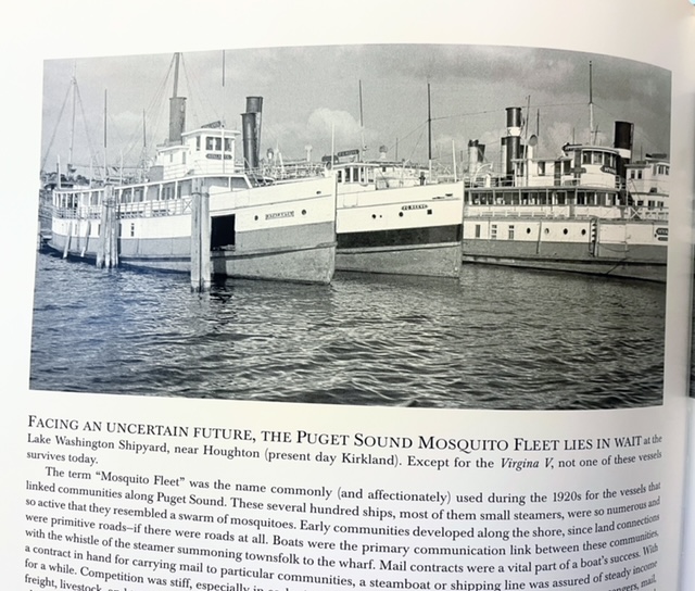
During the late 1930's the Mosquito Fleet were kept at the shipyard with an uncertain future. The Mosquito Fleet which includes the Virginia 5 was once the main way to move people around Puget Sound.

Photo from Northwest Legacy (Jeremy Snapp)


In World War 2 the shipyard built several vessels to support the war.  See the list on Wikipedia

In 1947 the shipyard was purchased and in 1960 it was closed.  Today the former shipyards are now Carillon Point, a residential and commercial area with a marina.  

Read more on the History Link 
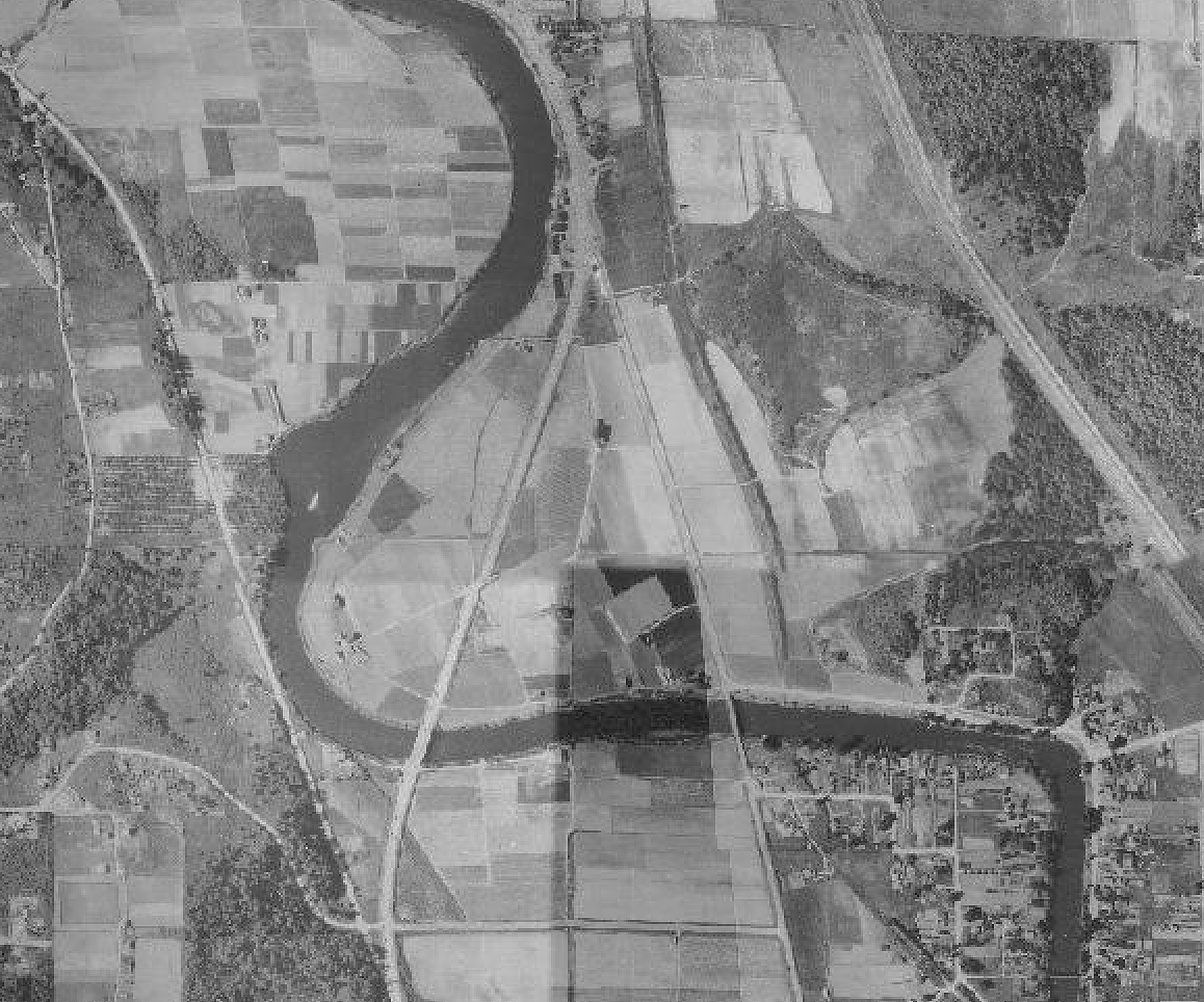


1936 Aerial view


The Mosquito Fleet images copied from the Northwest Legacy, Sail, Steam and Motorships, by Jeremy Snapp


North Winds Weir on the Duwamish River

The North Wind Weir on the Duwamish River in Seattle is where the river ends it's channelized section and moves into it's un-straightened shoreline.  

The weir is a narrow section of the river where at low tide a rock shelf is exposed and further narrows the river channel and a class 1-2 river rapid.  

It was once a fishing area for the Duwamish people. Due to the rapid the saltwater mostly ends at the weir making it a interesting mix of salt and freshwater thus good for salmon fishing. As a paddler I've been interested in it as it's Seattle's only whitewater rapid.

It's located at 27th avenue south where the Green River Trail crosses the river.

Read about recent salmon conservation efforts at the weir.


The weir has a story that follows its history - (From Wikipedia):

According to Salish tradition, North Wind stretched a weir of ice across the Duwamish River at this site; no fish could pass, starving the people up the valley, the people of the Chinook Wind who was married to North Wind's daughter Mountain Beaver Woman. The mother of Mountain Beaver woman survived the starvation, but retreated to the mountain. Mountain Beaver Woman's son, the child Storm Wind, also survived.[2]

The people of the North Wind warned Storm Wind to stay away from the mountain, trying to keep from him the knowledge of what had happened to his people, but eventually he defied them and found his grandmother living in misery. He heard her story and helped her out of her misery; she, in return, aided him with a flood that shattered the weir and turned it to stone. Storm Wind and his grandmother defeated North Wind, who only occasionally and briefly torments the area with snow and ice. (From Wikipedia - Alan Stein (2000-08-15), "Arthur Ballard records and translates the legend of origin of the North Wind Weir on the Duwamish River beginning in 1916"HistoryLink, Seattle: History Ink, retrieved 2016-10-24)


Read the full story of the North Wind Weir from History Link


The weir is in the middle left 

1936 aerial view (weir middle left)


11/14/22

Tillicum towing Kitsap out of Ballard, 1916

 I spend a lot of time paddling and walking the shorelines of Seattle's Salmon and Shilshole Bays and thinking about now and then perspectives.  

While browsing the Seattle Public Library Special Collections online last night I came across these images I've never seen before titled - Tillicum towing Kitsap out of Ballard, 1916 (spl_shp_40570)

And just behind the Kitsap is a dredger probably working to clear a channel below the newly constructed Ballard Locks just upstream.  

The image is shot from Magnolia looking NE towards Ballard and Sunset Hill. 


For me, there's a lot going on in these image. It's not just a majestic ship being towed out of Salmon Bay but I wonder if the foreground is Salmon Bay Charlie's (Hwehlchtid) land protruding into the channel before it was dredged?  


In the horizontal image the train bridge at NW 61st St is a bit further down to right suggesting that this could be Charlie's later dredged spot.  

Comparing a popular image of his place (below), the large cleanly cut beach log in the foreground looks familiar.  But this image is in 1905 and the Kitsap images (above) are 1916. The above images face the opposite direction.  

1905, Webster and Stevens Studio, UW Libraries.

I've been researching the Ballard shoreline where I spend a lot of time in the Elks Lodge and adjacent beach as an Elks Member and for my paddling business, Salmon Bay Paddle. The Elks Lodge would be built in the 1960's in the space between the dredger and the Kitsap.  

And further in the distance on the hill above the now Golden Gardens Park is a full growth of probably old growth trees, unlike the scene further to the south or (right) which was mostly logged in the 1870's. 


10/25/22

Hibulb the Snohomish Winter Village in Everett, WA

Hibulb also called the Heart of the Region was the main winter village for the Snohomish tribe for thousands of years. 

Located at the SW corner of the mouth to the Snohomish River in Everett, WA, the fortified village was abandoned in 1855 after the Point Elliott Treaty.  

Read more from History Link about the village and visit the Hibulb Cultural Center to learn more and see artifacts from the village.

In 2013 in Legion Memorial Park directly above the site the city of Everett held a celebration providing historical signs such as the first image here.  


6/14/22

Port Townsend Shoreline in 1792 and 2022

 In 1792, Captain Vancouver camped at Port Hudson in now Port Townsend to explore the area in 3 small boats.  

John Sykes illustrated this image showing the SE part of 'PT' with his crew in a canoe and native bird catching nets in the background.  

Spending some time in PT recently, I had the opportunity to get the 2022 photo at a minus tide in front of the Aladdin Hotel where we were staying during the Seventy48 and R2AK race weekend and 'Ruckus'.  

Read more about this visit by Captain Vancouver on the History Link site.. 

These images face East..


                                       Poles supporting nets to catch ducks, Port Townshend, 1792

                                    Engraving by John Sykes, Courtesy UW Special Collections (Neg. NA3984)


Taken in front of the Aladdin Hotel, minus tide 6/13/22


Wider view


4/14/22

"Seattle Waterfront. 1882-1886. Canoes and Indians in Belltown. Foot of Vine St. Cedar and Broad St. Photo by Asahel Curtis."

 From the Seattle Public Library Special Collections, a 1882 view of the Seattle waterfront at the approx base of Vine St. Cedar and Broad Streets by Asahel Curtis. (View in Collections)  Looking northeast.


Here's the approx 2021 view of the bottom of Vine Street from Google Earth looking NE.  The 1882 image and shoreline would've been around the location of the railroad tracks. The Seattle waterfront was extended out quite a bit beyond the original shoreline. 


Seattle’s waterfront (below), viewed from Bell Street in 1930.
 Courtesy of the Seattle Municipal Archives, item No. 4101. The 1882 view above would've been on the lower left below the hill in the image here, (Looking South)


3/30/22

Salmon Bay Entry Before and After Ballard Locks Dredging

Here's two glimpses of images showing Seattle's Salmon Bay's entry into Shilshole Bay before the Chittenden (or Ballard) Locks dredging and the current view.  

The Shilshole people called the mouth of Shilshole 'sHulsHOOLOOTSeed'

Originally the channel had a few sandbars stretching across and was wade-able at low tide.  Shilshole means 'like shoving a thread through a bead.'  

Before dredging, a large sandbar existed (seen here) on top right on the Ballard side just south of Ray's Boat house, called 'Hanging on the Shoulder' or KeehLalabud.'  The sandbar was known for good clamming. Photo: MOHAI. 

Dredging for the Locks occurred around 1915 ish.  

Photo by Wilse

The March 2022 photo below shows my surf ski parked on the Ballard side below Seaview Ave.  The tide is a touch higher than the older photo but in either case dredged sandbar would've been visible.  


As 'settlers' arrived and built logging mills upstream in downtown Ballard, boats could only enter or exit at high tide.  

The image above shows tall masted ships moored in Shilshole Bay probably waiting for the tide and their turn to enter the narrow mouth.  

Here's an 1890's view from Magnolia looking North towards the Salmon Bay 
entry into Shilshole Bay


Here's a 'Washington Territory' pre-Locks chart of the same area showing sand bars and undeveloped shoreline of Salmon and Shilshole Bays. 


Sources and Resources:

The above native terms were taken from Coll Thrush's 'Native Seattle' book by UW Press.  

Read also Paul Dorpat's post on this spot Here

And David William's book 'Waterway' on the history of Seattle's Ship Canal.