3/17/21

Changing beaches: Kalaloch

2 March 2014 photo taken of beach wood at the base of coastal bluffs on Kalaloch Beach in Olympic National Park. 


This post is a bit different, in that it focused on changes to shorelines over very short time-scales...a few years, probably driven by forces that don't have anything to do, at least directly, with people.  It will hopefully come as no surprise that shorelines are one of the most ever-changing landscapes on the planet, subject to pushes and pulls from both the water and the land.  They change all the time, so on some level it shouldn't come as any surprise that Kalaloch Beach in Olympic National Park has changed dramatically in the past few years.  I wanted to focus on the huge logs that are a very notable feature on the shorelines of Washington State, particularly on the north coast, and that used to pile up at the top of the beach near Kalaloch Lodge.  At some point in 2015, the logs accumulated on the beach near Kalaloch Lodge were stripped away, and haven't yet returned:

12 March 2021 photo of coastal bluffs on the beach near Kalaloch Lodge.

We still don't really understand why they were stripped off the beach here, and probably more importantly, why new large wood hasn't recruited back to the beach.  Its also not clear if the obvious erosion of the bluff at this location has anything to do with the removal of the large wood.  All that we know is that, in the space of just a few short years, the beach looks very different.


3/4/21

Duwamish River - A River with Big Change


The Duwamish River was straightened in 1913 after thousands of years as a natural flowing river whose tributaries originate below Mt Rainier.  

Home to the Duwamish people, Herring's House at the mouth to the now Elliott Bay had at least four longhouses and a huge potlatch house.  

Below is the Waterlines Project map sponsored by the Burke Museum.  The green dots are village sites. Blue are 'named places' or places of importance along the shoreline.  View the full map here

The below comparison is from the Duwamish River Clean-up Coalition page, view it here.


Read More about the Duwamish.. 

Native Seattle, Coll Thrush, UW Press

The River that Made Seattle, BJ Cummings, UW Press

Once and Future River, UW Press

Too High Too Steep, David Williams, UW Press

Chief Seattle, David Buerge, Sasquatch Books 


2/22/21

Hollywood Beach in Port Angeles, changing uses of the shoreline

Last year I posted a set of before/after photos of Hollywood Beach in Port Angeles, with a focus on how much large-scale fill has transformed Washington's urban shorelines.  This post is going to focus on the same area, but I'm going to try to emphasize the trade-offs, from a cultural and ecological stand-point, associated with that transformation.  I feel that this particular photo:

does this job well.  This photo, taken from right about here, ended up in my collection, but I don't know a whole lot about it...when it was taken, whose collection its in, etc. (and who should be credited for it; please get in touch with me if you know anything about it).  But this photo was definitely shot before downtown Port Angeles was filled around 1913, and gives us some perspective of both the uses (residences, canoes, etc.) and habitat conditions (a relatively broad, low-sloping beach and actively eroding coastal bluff) of this shoreline.  The view from this perspective is now radically different:

June 2015 photo looking east along the historic shoreline near Hollywood Beach in Port Angeles

These two photos aren't perfectly aligned, but are pretty close...


2/1/21

Seattle's Ballard Beach Pre-Shilshole Marina and Present Day

Seattle experienced big changes along it's shorelines in the 20th century.  In Ballard, Shishole Bay went from a rural gravel covered beach with forested hillsides to fully developed with filled in shores, pavement and residential areas.  

Ballard Beach pre-road (looking North to Golden Gardens)


Ballard Beach, 1920's looking South


Burke Gilman link, Seaview Ave and Shilshole Marina, 2021


Ballard Beach looking southwest towards the entry to Salmon Bay, Magnolia and West Point


From 34th NW street overlooking Shilshole Marina, approx 1960's, early marina days.


                               From the 34th NW St park overlooking Shilshole Marina 2021

1/31/21

Seattle's West Point Lighthouse - 1940 and 2021

I came across this 1940 photo in one of the Magnolia Historical Society's books 'Magnolia Memories'.  

What's significant about it is that it's before the sanitation facility was installed in the 1960's. 

History Link states "This low sand spit, made by the opposing currents on the sound, was known to the Duwamish Indians by "Per-co-dus-chule," or "Pka-dzEltcua," which translates "thrusts far out." It was known to early mariners as Sandy Point."  If you have flash, this is a great history of West Point link.

The shoreline is untouched on the south and north sides and the point aside from the 1881 era lighthouse depicts the other low points with a salt marsh seen elsewhere around the Sound such as Marrowstone Point. 

Lighthouse Friends points out that Seattle's raw sewage poured out onto the seemingly pristine beaches making for quite a stink. 

The young man in the photo probably didn't know what was coming his way with WW2 starting in the US later the next year.   

As a paddle surfer, I like the boat wakes in the lower left image probably by the boat that just passed the point upper right.  These days we surf small and freighter size surf along West Point.  


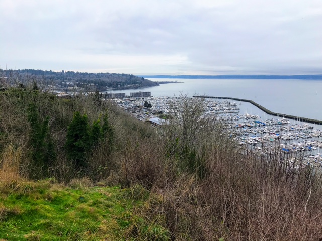
The now image isn't as exciting. Bluff erosion and heavy foliage kept me from being more to the left as the before image depicts.  I shot the image in January for better visibility through the trees.  

There's a path with a wooden railing leading to the view from the main road.  


Google Earth cropped view from (5/26/2018).  North -->

Posted by Rob Casey, 1/21


1/6/21

English Camp Blockhouse and shoreline

The Blockhouse at English Camp on San Juan Island.  Photo collected 2 December 2020

I first visited English Camp in the early 1990's as a college student on a spring break bike trip.  I was as struck then as I am now by what is known as the Blockhouse, sitting on the wet marshy edge of  Garrison Bay.  This building dates to the 1860's and is notable both for its design and location, which strikes as me as fairly unique for the Pacific Northwest, and also for its relatively good state of repair given its location in the upper intertidal.  If you pulled up to this shoreline around 1915 you would have been greeted by a very similar view of the Blockhouse:

Photo of the Blockhouse, circa 1915.  Photo from the University of Washington Special Collection.

The building is treated well now, as it is managed by the National Park Service, but it is astonishing that it survived through many decades of private ownership between when the English departed in 1876, and when the NPS took over the management of this site in the 20th century.  The 1915 photo above was taken after at least 30 years of the site and buildings being used as a homestead and farm, with the waters of Garrison Bay lapping at the base of the structure the whole time.  

12/3/20

Patos Island Light Station


1940 photo, taken from the water (about here), of the Patos Island lighthouse station. Photo from Wikimedia Commons.

Patos Island is one of the outer islands in the San Juan archipelago, and has been a point of fascination for my family this fall due to the riveting stories in Helene Glidden's Light on the Island.  We were eager to make a trip out to the island to explore the light station and try to place the many stories in the book, which is a fictionalized account of Helene Glidden's childhood there in the early 20th century.  Patos Island is out there (20 nautical miles from Friday Harbor) and exposed (weather conditions have to be good) but we finally made the trip and found that, unlike many of the light stations around the Salish Sea that we have visited (and that are featured in this blog), the modern scene on Patos looks quite a bit different:

28 November 2020 photo of the Patos Island light station, shot from the water.

I didn't quite hit the photo perspective just right - notably the white band in the modern photo is a concrete foundation of the building that is furthest to the right in the historical image, and suggests that I include more of the island in my modern perspective than the historic photo does.  Despite that, though, the differences in the perspectives are clear.  Unlike many light stations in the Salish Sea, most of the buildings that used to make up the light station are now gone.