1/6/21

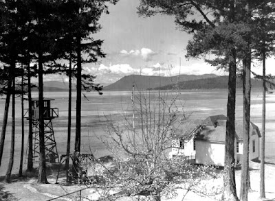
English Camp Blockhouse and shoreline

The Blockhouse at English Camp on San Juan Island.  Photo collected 2 December 2020

I first visited English Camp in the early 1990's as a college student on a spring break bike trip.  I was as struck then as I am now by what is known as the Blockhouse, sitting on the wet marshy edge of  Garrison Bay.  This building dates to the 1860's and is notable both for its design and location, which strikes as me as fairly unique for the Pacific Northwest, and also for its relatively good state of repair given its location in the upper intertidal.  If you pulled up to this shoreline around 1915 you would have been greeted by a very similar view of the Blockhouse:

Photo of the Blockhouse, circa 1915.  Photo from the University of Washington Special Collection.

The building is treated well now, as it is managed by the National Park Service, but it is astonishing that it survived through many decades of private ownership between when the English departed in 1876, and when the NPS took over the management of this site in the 20th century.  The 1915 photo above was taken after at least 30 years of the site and buildings being used as a homestead and farm, with the waters of Garrison Bay lapping at the base of the structure the whole time.  

12/3/20

Patos Island Light Station


1940 photo, taken from the water (about here), of the Patos Island lighthouse station. Photo from Wikimedia Commons.

Patos Island is one of the outer islands in the San Juan archipelago, and has been a point of fascination for my family this fall due to the riveting stories in Helene Glidden's Light on the Island.  We were eager to make a trip out to the island to explore the light station and try to place the many stories in the book, which is a fictionalized account of Helene Glidden's childhood there in the early 20th century.  Patos Island is out there (20 nautical miles from Friday Harbor) and exposed (weather conditions have to be good) but we finally made the trip and found that, unlike many of the light stations around the Salish Sea that we have visited (and that are featured in this blog), the modern scene on Patos looks quite a bit different:

28 November 2020 photo of the Patos Island light station, shot from the water.

I didn't quite hit the photo perspective just right - notably the white band in the modern photo is a concrete foundation of the building that is furthest to the right in the historical image, and suggests that I include more of the island in my modern perspective than the historic photo does.  Despite that, though, the differences in the perspectives are clear.  Unlike many light stations in the Salish Sea, most of the buildings that used to make up the light station are now gone.  


11/25/20

Turn Point Light Station

WWII era photo of the Turn Point light station, with a military observation tower in the left of the image.  Image from Wikimedia Commons

Turn Point on Stuart Island marks the ragged and liquid edge of the contiguous United States, and like many of the most northerly rocky points of the San Juan Islands, it is graced with a historic lighthouse that helped (and still helps, though now with an automated light) to guide ships along the channels between Canada and the United States.  And, like many of the historic light stations, it is in very good repair, such that if you were a visitor to this place from the turn of the century you might not immediately know that you had arrived in 2020.  Case in point, the image above is ~80 years old, and the scene today is different only in minor detail:

1 November 2020 photo of the Turn Point light station, looking north from the Keeper's house

The most notable difference is the observation tower at left in the photo, which was used as an observation post during WWII...another symbol of changing uses of Washington's shoreline.

11/18/20

Friday Harbor Laboratories, an early version


Photo of one of the early iterations of what is now the University of Washington's Friday Harbor Labs.  Photo courtesy of the University of Washington's Special Collections.

The photo above dates to between 1909 and 1924, and is of a location on the shorelines of Friday Harbor on San Juan Island (about here).  The building in the forefront of the photo still sits on the shoreline, and was used as one of the early sites of what has become the University of Washington's Friday Harbor Labs.  My guess is that those tents perched on the hillside hosted students, and according to the history linked above, the site was eventually abandoned in favor of the Lab's current location here due to the steepness and muddiness of this location.  That steepness and muddiness, though, did not prevent the site from developing through time, though, and those tents have been replaced with some very high value real estate on the outskirts of the town of Friday Harbor.  Here is the contemporary view:

15 November 2020 photo of the shoreline of Friday Harbor, Washington


11/13/20

Landing craft on the beach at Fort Worden

 A quick post today from Fort Worden in Port Townsend. I mostly want to use this post to amplify the great work by Fort Worden historian Tim Caldwell with his regular column in the Port Townsend Leader newspaper. Kudos to the newspaper and the community for continuing to celebrate and share the story of this special place. 

Tim shared this same historical photo of landing craft on the beach at Point Wilson earlier this year. Please enjoy Tim's history behind this photo at the Port Townsend Leader's website and enjoy my now photo here for comparison:

Point Wilson at Fort Worden Then (1950) and Now (2020)
(Historical photo courtesy of the Jefferson County Historical Society)

In the distance you see the Point Wilson lighthouse, which has stood since 1879, although it was rebuilt in 1914. It was built on a very sandy beach and the shoreline to the north was heavily armored in an effort to protect the lighthouse and associated buildings from the large wind waves from the Strait of Juan de Fuca that pummel the beach and threatened the integrity of these structures. The negative effects of shoreline armoring obviously weren't known in those days. 

Please visit this page from the National Archives to see photos of the previous lighthouse and the beach before the riprap was placed. For more information about the history of the lighthouse, please visit lighthousefriends.com, and for current information please visit pointwilsonlighthouse.org


:


10/30/20

Friday Harbor's shoreline


I believe that this photo is in the special collections of the University of Washington.  Link needed though.

A short-term teaching residency at Friday Harbor Laboratories means that I will have the chance to create some of the trademark now-and-thens for the shorelines of the San Juan Islands...and where better to start than at Friday Harbor Laboratory itself.  The photo above isn't all that old...it was shot in 1952, roughly three decades after the labs took root on this spot on the northern shore of Friday Harbor.  As the labs have developed this chunk of shoreline hasn't changed all that much, outside of the growth of trees along the shoreline:

29 October 2020 photo 

I am struck by one thing though in the 1952 photo - the amount of wood that appears to be accreted to the shoreline looks to be quite a bit more than at present.  There are probably good reasons for this - logging and log transport via tug-and-raft arrangements was presumably more common in the middle of the 20th century.  


10/19/20

A look at a buried tide flat


The photo above is another from Port Angeles, and is part of an extensive series of photos that appear to all have been taken as the downtown area was being filled in 1914.  Many of this series are part of the Bert Kellogg collection, hosted by the North Olympic Library, but this particular photo doesn't appear to be available in that collection.  I obtained this photo from Dr. Karl Wegmann, who had collected a large set of historic photos of Port Angeles to support a report to the City of Port Angeles, and a subsequent paper.  

This particular photo was taken right about here, and the view from the same perspective looks considerably different today:

16 October 2020 photo taken looking southeast from the corner of Railroad and Laurel in downtown Port Angeles, Washington.

I like this particular historic photo because you can make out the intertidal flats that would have fringed Port Angeles harbor historically.  From the looks of it I'm guessing that it was prime habitat for clams, birds and fish, and it would have been quite cool to check out.  Its still there of course, but buried under many feet of fill...