10/7/21

Restoration and change on the Elwha River delta

 Another perspective on short-term change on the shoreline associated in part with restoration (like this post from June), again on the Elwha River delta (like this post from 2020).  This particular location is on the east side of the Elwha River delta, and was eroding rapidly between 2011 and 2015.  Here is what the site looked like in 2011:

May 2011 photo of the beach on the Elwha River delta, looking up the beach from the low tide line.  

By late 2013 the beach was heavily eroded, revealing large boulders on the beach, part of a failed defensive rip-rap structure built at some point in the past:

September 2013 photo

By Summer of 2016 sand associated with the removal of two dams on the Elwha River was moving through this area, but not in quantities adequate to re-bury those big rip rap boulders, or rebuild the beach to its 2011 position:

July 2016 photo

Later in the summer of 2016, though, those rip-rap boulders were removed as part of a restoration project, and the sediment from the dam removal kept pumping along the beach, so by 2018 the beach looked very different at this location:

July 2018 photo


9/5/21

Mistaken Identity - #2 - Seattle's Alki Point or Orcas Island?

 At least one historical hard cover Seattle photo history book and a HistoryLink post on Alki Point have presented this image as 'A Outing near Alki Point', 1889.  (Alki Point is in Seattle)


When I saw both publications, the image didn't quite feel like Alki or anything near Seattle.  

The large hill or mountain in the background seemed too tall and too close to be in Seattle.  

Often telephoto lenses can squeeze elements together and bring mountains closer to the foreground, but I assume the photographer didn't have a 600mm lens in 1889, even on a view camera.  

So I posted the image on the Facebook group "Puget Sound and Surrounds."  Everyone who responded agreed it's definitely not Seattle.  Maybe Chuckanut Drive, Hood Canal or.. the San Juans? 

It was decided through similar photos and Google Earth that it was Orcas Island!  

Here's the results! 


Post by Emily Wilmot - 


Posted by:
Ivan Dennison
The rocks these people are sitting on are still there (as is the landing on the opposing shore) and visible just to the left of the icon for the Inn.


Mistaken Identity - Blake or Waadah Island?

 I follow the Facebook group History of Puget Sound and Arounds whose followers post common and sometimes less known PNW history photos.  

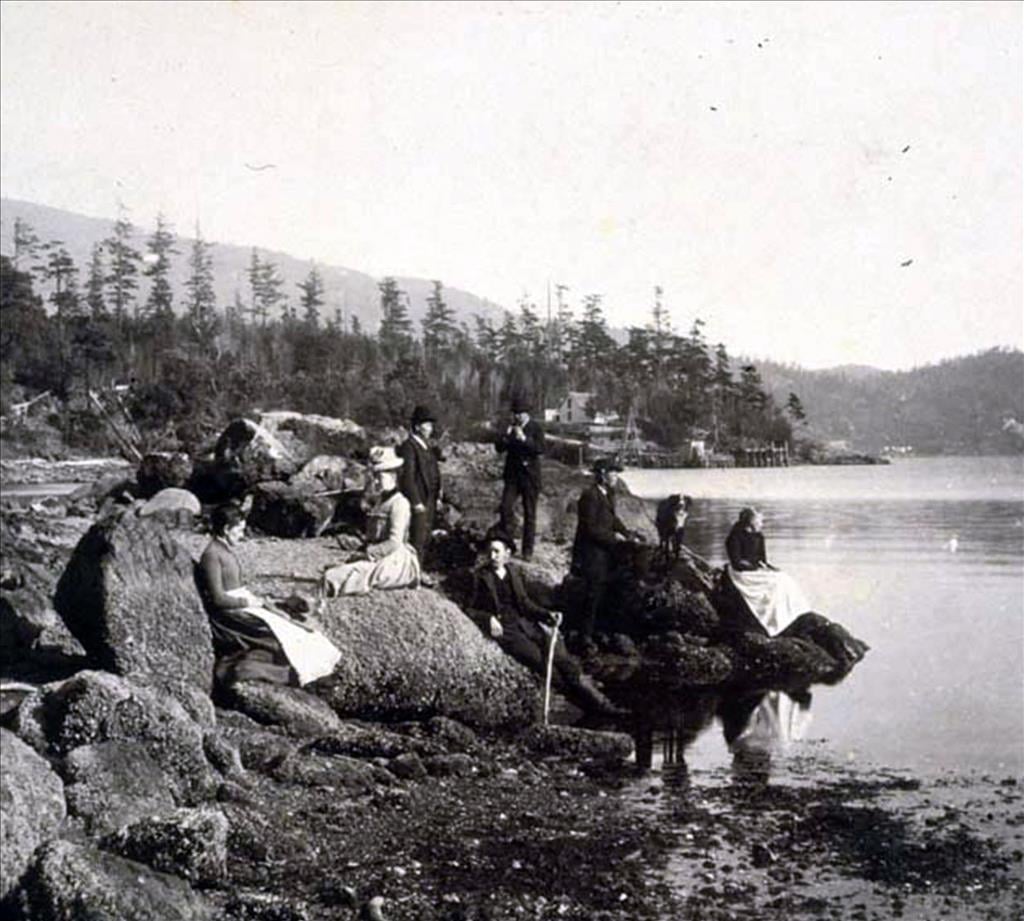
In November 2019, group admin shared a post from another FB group showing this postcard from the early 20th century showing 'Puget Sound Indians' on the beach after fishing. 

Group members felt the location was Blake Island, across from Seattle.

Right off, I knew it was Waadah Island, which borders Neah Bay.  I've surfed around Neah Bay for years so know the area well.  

When you enter Neah Bay, you can view Waadah Island as you just arrive in town.  The island was connected to the shoreline at some point thus protecting the bay and its fishing fleet from ocean swell.

Below is the postcard and post from the history group.  

Further below are images I found showing the island in different eras including (middle) the image from the book "The Sea is My Country."


8/9/21

Sekiu and the schooner Louise

 This 1909 photo of the schooner Louise S. on its side in Sekiu is featured in an interpretive display about shipwrecks at Clallam Bay State Park, and I've always found it arresting.  

The schooner Louise S. aground just offshore of Sekiu, WA in 1909.  Photo from the Bert Kellogg collection.  

The ship itself provides a glimpse into a time period on the Olympic Peninsula when boats like this would have been a common sight sailing from coastal town to coastal town.  But the other thing, of course, that this photo features is in the background...the shoreline of Sekiu.  And just as the ship speaks to changes in our modes of transport, the shoreline in this 1909 photo speaks to changes in the shoreline.  Here is the modern view from more or less the same spot:

8 August 2021 photo of the boat haven in Sekiu, Washington, taken about here.

The changes here made it hard to orient the photo, but I tried to focus on the iconic Three Sisters (here is a closer-up historical view of them), which are barely visible in the modern photo, sticking out of a parking lot behind the boats.  The shoreline here has been filled and, obviously, a breakwater built to create the modern boat haven.  I can't find much online about the history of the breakwater, fill or the marina in general, so if anybody knows more please reach out.


7/9/21

The Irondale Steel Mill

 This one happened by accident...I happened to be down at the beautiful Irondale County Beach Park with my kids and just decided to poke around the Bert Kellogg collection for photos from Irondale.  I had no idea that this was the site of one of the first major industrial endeavors in Western Washington, the Irondale Iron and Steel Plant built in 1881.  This photo from sometime around the turn of the 20th century gives a sense for the scale of the site:

Turn of the century photo of the Irondale Iron and Steel Mill, taken from about here.  Photo from the Bert Kellogg collection.

The modern view (or as close to it as I could figure out how to get):

5 July 2021 photo taken here.

At low tide various pilings and cement footings are still visible on the beach here, presumably that were associated with the buildings and wharfs of the mill.  And while I didn't explore more of the site, it looks as if there might be a lot of history still visible in the trees if you poke around.  In the distance in both the historic and modern photo is Kala Point, with an apparently nearly identical copse of trees visible in both photos, and then behind that the shoreline of Port Townsend.  


6/27/21

Port Crescent, Revisited from the Water

We’ve posted about the lost logging town of Port Crescent on this blog before, but there are so many great historical photos of the townsite, it’s worth revisiting. This time our view is from the waterside with the 500 ft. wharf and Markham hotel just as prominent as in our previous post.

Port Crescent then (1902) and now (June 2021)

As always, I encourage you to examine the historical photo (another from the Bert Kellogg Collection) on the Washington Rural Heritage website. The most interesting details to me are the train engine on the wharf and the tug tied up at the end of the wharf.

Port Crescent was booming in the late 1800’s, along with many towns on the Olympic Peninsula. At its peak, the town was populated by between 600-700 people. The timber industry and prospects of becoming the terminus of a transcontinental railroad line brought investors and money.

In 1890, three Clallam County towns were in competition to be the country seat, at the time located in New Dungeness. Port Crescent and New Dungeness lost out to Port Angeles and the rest is history. The railroad never came to Port Crescent and neither of the losing towns exist today.   

As a bonus, here is a second view of Port Crescent facing west from the water. You can view the original historical photo here

Port Crescent then (date unknown) and now (June 2021)


References:

6/9/21

The Dungeness Pier, a look to the south

For a while I've been wanting to try to replicate this 1909 photo looking south from  a spot out in Dungeness Bay (about here):

1909 photo looking south, taken from the deck of the old Dungeness pier.  Photo from the Burt Kellogg collection.  

There are a few things that are just arresting about this photo - notably that its a panorama view, made of multiple photos physically aligned and presumably taped or glued together, and that it was taken from the now-gone Dungeness pier.  The pier was really quite long...3/4 mile when it was originally built in 1890-91...and it really had to be to reach deep water at the edge of the active delta of the Dungeness River.  This pier was the key bit of infrastructure connecting the products derived from forests, ag land and waterways of the Sequim prairie to the rest of the world, and the pier served the larger cargo boats and ferries that were calling at Dungeness at the time.

I finally had the chance today to try to recreate this view while I was on my way out to Dungeness Spit by boat:

9 June 2021 photo looking south from the water...

Its actually quite hard to confirm that I've got it exactly right...but its close at least.  The mountains provide good clues in the background, but today's clouds obscured some key summits.  Interestingly its really quite hard to place some of the closer landscape features in the historic photo, perhaps because the landscape has changed so dramatically in this area (it is, after all, an active river delta).  This paper by the University of Washington's Brian Collins is a really fascinating and rich description of those changes...and well worth a look, if not a full read.  

 According to this article the dock served a useful life for about 50 years, after which it decayed until its removal as part of a restoration project in 2018-19.  Its still visible in many aerial photographs, and of course blog co-conspirator Shanon Dell had the same idea as I did, but acted on it much sooner, collecting this photo in December 2014, before the pier remnants were removed:

December 2014 photo by Shanon Dell