12/3/20

Patos Island Light Station


1940 photo, taken from the water (about here), of the Patos Island lighthouse station. Photo from Wikimedia Commons.

Patos Island is one of the outer islands in the San Juan archipelago, and has been a point of fascination for my family this fall due to the riveting stories in Helene Glidden's Light on the Island.  We were eager to make a trip out to the island to explore the light station and try to place the many stories in the book, which is a fictionalized account of Helene Glidden's childhood there in the early 20th century.  Patos Island is out there (20 nautical miles from Friday Harbor) and exposed (weather conditions have to be good) but we finally made the trip and found that, unlike many of the light stations around the Salish Sea that we have visited (and that are featured in this blog), the modern scene on Patos looks quite a bit different:

28 November 2020 photo of the Patos Island light station, shot from the water.

I didn't quite hit the photo perspective just right - notably the white band in the modern photo is a concrete foundation of the building that is furthest to the right in the historical image, and suggests that I include more of the island in my modern perspective than the historic photo does.  Despite that, though, the differences in the perspectives are clear.  Unlike many light stations in the Salish Sea, most of the buildings that used to make up the light station are now gone.  


11/25/20

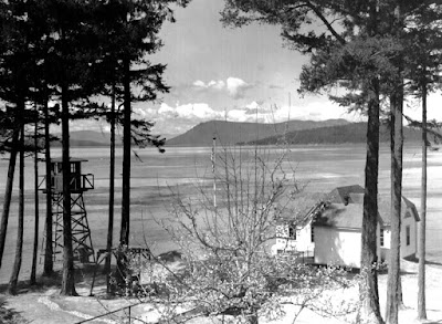
Turn Point Light Station

WWII era photo of the Turn Point light station, with a military observation tower in the left of the image.  Image from Wikimedia Commons

Turn Point on Stuart Island marks the ragged and liquid edge of the contiguous United States, and like many of the most northerly rocky points of the San Juan Islands, it is graced with a historic lighthouse that helped (and still helps, though now with an automated light) to guide ships along the channels between Canada and the United States.  And, like many of the historic light stations, it is in very good repair, such that if you were a visitor to this place from the turn of the century you might not immediately know that you had arrived in 2020.  Case in point, the image above is ~80 years old, and the scene today is different only in minor detail:

1 November 2020 photo of the Turn Point light station, looking north from the Keeper's house

The most notable difference is the observation tower at left in the photo, which was used as an observation post during WWII...another symbol of changing uses of Washington's shoreline.

11/18/20

Friday Harbor Laboratories, an early version


Photo of one of the early iterations of what is now the University of Washington's Friday Harbor Labs.  Photo courtesy of the University of Washington's Special Collections.

The photo above dates to between 1909 and 1924, and is of a location on the shorelines of Friday Harbor on San Juan Island (about here).  The building in the forefront of the photo still sits on the shoreline, and was used as one of the early sites of what has become the University of Washington's Friday Harbor Labs.  My guess is that those tents perched on the hillside hosted students, and according to the history linked above, the site was eventually abandoned in favor of the Lab's current location here due to the steepness and muddiness of this location.  That steepness and muddiness, though, did not prevent the site from developing through time, though, and those tents have been replaced with some very high value real estate on the outskirts of the town of Friday Harbor.  Here is the contemporary view:

15 November 2020 photo of the shoreline of Friday Harbor, Washington


11/13/20

Landing craft on the beach at Fort Worden

 A quick post today from Fort Worden in Port Townsend. I mostly want to use this post to amplify the great work by Fort Worden historian Tim Caldwell with his regular column in the Port Townsend Leader newspaper. Kudos to the newspaper and the community for continuing to celebrate and share the story of this special place. 

Tim shared this same historical photo of landing craft on the beach at Point Wilson earlier this year. Please enjoy Tim's history behind this photo at the Port Townsend Leader's website and enjoy my now photo here for comparison:

Point Wilson at Fort Worden Then (1950) and Now (2020)
(Historical photo courtesy of the Jefferson County Historical Society)

In the distance you see the Point Wilson lighthouse, which has stood since 1879, although it was rebuilt in 1914. It was built on a very sandy beach and the shoreline to the north was heavily armored in an effort to protect the lighthouse and associated buildings from the large wind waves from the Strait of Juan de Fuca that pummel the beach and threatened the integrity of these structures. The negative effects of shoreline armoring obviously weren't known in those days. 

Please visit this page from the National Archives to see photos of the previous lighthouse and the beach before the riprap was placed. For more information about the history of the lighthouse, please visit lighthousefriends.com, and for current information please visit pointwilsonlighthouse.org


:


10/30/20

Friday Harbor's shoreline


I believe that this photo is in the special collections of the University of Washington.  Link needed though.

A short-term teaching residency at Friday Harbor Laboratories means that I will have the chance to create some of the trademark now-and-thens for the shorelines of the San Juan Islands...and where better to start than at Friday Harbor Laboratory itself.  The photo above isn't all that old...it was shot in 1952, roughly three decades after the labs took root on this spot on the northern shore of Friday Harbor.  As the labs have developed this chunk of shoreline hasn't changed all that much, outside of the growth of trees along the shoreline:

29 October 2020 photo 

I am struck by one thing though in the 1952 photo - the amount of wood that appears to be accreted to the shoreline looks to be quite a bit more than at present.  There are probably good reasons for this - logging and log transport via tug-and-raft arrangements was presumably more common in the middle of the 20th century.  


10/19/20

A look at a buried tide flat


The photo above is another from Port Angeles, and is part of an extensive series of photos that appear to all have been taken as the downtown area was being filled in 1914.  Many of this series are part of the Bert Kellogg collection, hosted by the North Olympic Library, but this particular photo doesn't appear to be available in that collection.  I obtained this photo from Dr. Karl Wegmann, who had collected a large set of historic photos of Port Angeles to support a report to the City of Port Angeles, and a subsequent paper.  

This particular photo was taken right about here, and the view from the same perspective looks considerably different today:

16 October 2020 photo taken looking southeast from the corner of Railroad and Laurel in downtown Port Angeles, Washington.

I like this particular historic photo because you can make out the intertidal flats that would have fringed Port Angeles harbor historically.  From the looks of it I'm guessing that it was prime habitat for clams, birds and fish, and it would have been quite cool to check out.  Its still there of course, but buried under many feet of fill...

10/9/20

Flagler's guns come ashore at Marrowstone Point

My favorite place to visit here on the Olympic Peninsula is Fort Flagler on Marrowstone Island. The former coast artillery fort is now a state park offering the best views of Puget Sound you can hope to find, including powerful currents and marine wildlife to watch, historical military structures to explore, and let’s toss in a lighthouse (well, sort of) for good measure. All these features make it an endlessly entertaining place to visit for a day, a weekend, or longer.

The historical photo for today’s blog post really blew my mind when I first saw it. It's a shot of Marrowstone Point from 1898, when Fort Flagler was under construction. I hope you enjoy my now photo, but you really should go to Jefferson County Historical Society’s site and look at the original historical photo. There are so many fascinating details to spot. Those are enormous cannon barrels being brought ashore from a barge on the beach. And in the distance on the left is the Marrowstone Light Station keeper's residence.

Marrowstone Point at Fort Flagler in 1898 and 2020
(Historical photo courtesy of Jefferson County Historical Society

Construction of Fort Flagler began in 1897 but the U.S. government was active here a decade earlier in the interest of maritime safety. A light to guide mariners has shone at Marrowstone Point in one form or another since 1888, but not from the traditional lighthouse tower that most of us would think of. Starting with a lens lantern mounted on a pole, the light eventually was erected atop a 20 ft. concrete building where it has been located since 1918. 

The light keeper's residence in both our now and then photos has acted as sentinel, standing at the shoreline since 1896. Just offshore, Puget Sound's unwieldy winds and dense fog can make navigating the strong currents rushing through narrow Admiralty Inlet a harrowing experience for vessels of any size. One calamitous event happened here in 1892 when the freighter S.S. Willamette rammed the S.S. Premier at full speed, killing five and injuring 18. Although neither ship sank, the damage to the Premier was significant to say the least. Take a look for yourself.  😮

The light still shines, now automated, but since the mid-1970s the site and structures have primarily served federal scientific research as the U.S. Geological Survey’s Marrowstone Marine Field Station. Their current work is focused on fish and overall marine ecosystem health. The light keeper's residence provides lodging for visiting scientists.

Marrowstone Point 1895 map
(National Archives)

I have not been able to track down information on the barn or other buildings we see in the historical photo. But on a map of the fort from 1913, the buildings are labeled as “old stables” and “old laundry.” Structures also appear on a map from 1895, but have no information. If anyone knows more, please share.

Fort Flagler 1913 map
(National Archives)

In addition to these maps, the National Archives website has several interesting photos including the document below showing the earlier structure on which the light was placed, and the front of the keeper's quarters with its fog bell. Both structures still stand and can be seen today (minus the bell).

1915 images of Marrowstone Point Light Station
(National Archives)


Sources: 

10/4/20

Ennis Creek, A look down from above

1887 photo of the mouth of Ennis Creek on the Strait of Juan de Fuca.  Photo from the Bert Kellogg collection, hosted by the North Olympic Library System.

The perspective above, of the mouth of Ennis Creek on the central Strait near present day Port Angeles, really intrigues me.  Not only does this photo date to 1887, which is an old image for this part of Washington, but it is also looking down on the creek mouth and hamlet from above...a somewhat rare perspective for old photos like this.  The area around the Ennis Creek mouth has been heavily used, and modified, over time: Originally a Klallam village site, then the settlement site for the Puget Sound Cooperative Colony (shown in the 1887 photo above), then utterly transformed by the construction of the Rayonier Mill in 1927.  The site is now home to the Olympic Discovery Trail, and also is the site of an active toxic clean-up program.  As a consequence, the landscape now looks very different:

September 18, 2020 photo of the mouth of Ennis Creek, looking down from bluffs to the west of the site.


9/15/20

Where once there was a beach....

Filling the former beaches and estuaries of Washington's coast to create the urban shorelines that we now see has to be one of the single biggest changes made to our coastal landscape in the historical period.  Fill is ubiquitous along urban shorelines in the Salish Sea...and I often assume that the process of filling these shorelines, which basically involved moving massive quantities of mixed sediment into the intertidal zone, must have been traumatic to the coastal ecosystems.  This set of photos from near the mouth of Valley Creek in Port Angeles also clearly illustrates just the simple loss of habitat that filling brought with it.  This is an interesting view looking landward from the very mouth of the creek, taken I'm guessing in the late 1800's:

Looking landward from near the mouth of Valley Creek, Port Angeles.  Photo from the Bert Kellogg collection, hosted by the North Olympic Library System.

The photo itself focused on the first electric light generating station in Port Angeles, in the white building on the hill.  But it also provides a view of the former shoreline near Valley Creek.  The perspective from the location is now quite different:

4 March 2014 photo by Ian Miller

The modern view really hammers home the massive changes that filling has wrought on Washington's urban shorelines.


8/31/20

Another view of Ozette

I posted about the Makah village of Ozette a few weeks back, and went back out to the site last week to do some survey work with staff from the Makah Tribe.  While there I had the chance to replicate a historical picture of the village that was given to me by Paul Gleeson, former Cultural Resources Director for Olympic National Park, and former site manager at the Ozette archeological dig (Paul is mentioned in this article about the dig).  So Paul passed on this photo, that he suggested was likely taken in the late 1800's or early 1900's:


To be clear, I DON'T know where this photo came from, or who to credit for its appearance here (if a reader does know more about this photo, please reach out).  But it is such an interesting perspective on the village site, as it is shot from Tskawahyah Island, so provides some sense for both the southern stretch of the village site, and also what the village would have looked like approaching from the sea (which presumably was the way that most people arrived and left from the village back at this time).  Here is the contemporary view from the same spot:

View of the Ozette Village site taken on 24 August 2020

This modern photo was obviously taken at a lower tide, but some of the sea-stacks, and even individual boulders and small rocks in the inter-tidal are shared in both photos.  There are obvious differences in the vegetation on the slopes behind the village - probably not a surprise given how many people lived here.  What I really like about the historic photo, though, is it provides a sense for how far south on this point people lived...well into the area that is now part of Olympic National Park and heavily used by backpackers for camping.  


8/24/20

Ballard Shoreline Aerial Comparisons - 1940 and 2020

 Here's a fun comparison of the 1940's Ballard / Seattle shoreline and the current view from Google Earth.  

The now view is of the Seaview Avenue shoreline at the entry to Salmon Bay and Shilshole Bay at the location of the now Ray's Boathouse, former Anthony's, Ballard Elks Club, Sunset West Condos and the south corner of Shilshole Bay Marina.  

The bit of land across the channel is the NE corner of the Magnolia neighborhood.  

The 1940 view shows a different less developed shoreline with the reindeer ship, the SS Bering beached in front of the now Elks Club.  In the 1940's, the Tregoning Boat Company was located there.  

I believe the Ballard ferry landing was just south of (or above here) of Ray's Boathouse (to Port Ludlow and Suquamish).

The older photo also shows more beach homes across from Seaview Ave. Only a few are left now along with a few condos and misc buildings.  

From a surfing perspective, Point Shilshole is the point of land jutting out in the older photo. There's a nice wind swell rolling in and whitewater just offshore and along the shore.  

Looks like a good surf spot. We surf freighter and wind waves on Shilshole Bay so without the extra development and marina, we'd have one more downwinding and shore break spot!


Below is a Now and Then view from the Ballard Elks Lodge with the SS Bering looking out into Shilshole Bay. The ship was burned to make way for development in the early 1960'.  Now view from the Ballard Elks Sunset Cam.


8/8/20

Ballard Boat Works 1905 and Present

Sivert Engelsen Sagstad, a young Norwegian boat builder emigrated to Seattle and opened Ballard Boat Works, pictured here on lower Salmon Bay, pre-Locks in 1905.

I paddle past this shoreline weekly and have been trying to look for any early evidence of his boatyard and as well as any Shilshole tribal evidence which was prevalent along the shoreline prior to the boatyard.

When the Ballard Locks were being developed some of the shoreline below the boatyard was removed. In the 1905 mage, note that the shoreline had a gentle slope to the water.  In the Now images, the shoreline is shorter and abruptly drops to the water. 

Read more about Sagstad and the 70' Viking ship replica in this article from HistoryLink..  Read the HistoryLink story 

Now view from Seaview Picnic Park

Ballard Boat Works in 1905 and 'Now' view from Seaview Picnic Park

'Now' view from Seaview Picnic Park (location of yellow arrow)

2020 view of approx Ballard Boat Works location.  Photo: Salmon Bay Paddle


8/5/20

Dungeness Spit: The Lighthouse, Part 1

Yesterday I wrapped up the last of three days of annual shoreline survey work on Dungeness Spit, which took me out to the lighthouse area.  The scene here is completely different than what you find on Ediz Hook, in the sense that visiting the lighthouse on Dungeness Spit is a lesson in constancy...at least over the historical period.  Here is what I mean.  This is a photo from the turn of the century (exact date unknown) of the lighthouse complex on the end of Dungeness Spit:
Turn of the century photograph of the New Dungeness Lighthouse, originally built in 1857.  Photo from the Bert Kellogg collection, hosted by the North Olympic Library System.  

Here is roughly the same view (I didn't get the perspective quite right), approximately 120 years later:
7 June 2020 photograph of the New Dungeness Lighthouse.

Its amazing to me how much is similar between these two photos.  I'm sure there is a long story behind how this amazing set of structures has been preserved, but my suspicion is that a lot of the credit probably goes to the New Dungeness Light Station Association, an organization dedicated to the maintenance of this place.  

There are, of course, some interesting differences that I didn't note until I had the chance to examine these photos carefully.  First off, the light tower itself is shorter...apparently due to a tower shortening project conducted in 1927 (see the history assembled here).  A few buildings are missing - a fog signal building and privy, for example, that are shown in the historic image above aren't in the modern view.  In the historic view you can also make out a tram on rails that ran to a dock, and was used for transporting supplies from off-loading ships to the lighthouse.  There is no trace of that tram in the modern photo above though you can find bits and pieces of it still scattered in the adjacent dunes:
4 August 2020 photo looking east from a point west of the New Dungeness Lighthouse, showing what I take to be pieces of an old tram used to move supplies between a dock and the lighthouse.

7/22/20

Ruby Beach, Olympic National Park

Complementing last week's post about Ozette village, lets stay out on the coast for a bit.  Back in June the Forks Forum published a historic photo of Ruby Beach that dates, I think, to the 1930's.  Here it is:
Photograph of Ruby Beach, probably from the 1930's.  Unknown source, but published by the Forks Forum on their Facebook page on June 18.  
This photo really blew me away, as I had no idea that this site, which is now a very popular hike-in day use area along Olympic National Park's coastal strip, was used in this way.  The site is striking, in part because of the very prominent sea stacks and promontories visible in the background of this photo...which also make the modern perspective very easy to recreate.  A few weeks ago I did just that after a visit to Kalaloch to do some field data collection.  Here is the modern view:
Photograph of Ruby Beach, 26 June 2020.
If you look closely at these two photos you can also note some very minor, but obvious, landscape changes along the bank of Cedar Creek in the near field, and to the sea stacks in the far field.   Rocky stacks along Washington's coast seem permanent, but are continually changing and eroding...a process that we typically can't "see" unless we have the chance to view the changes over long time-spans, like the roughly 80-90 intervening years between these two photos.

7/15/20

Ozette...another (not) "lost" community

A few weeks ago I posted about Port Crescent, calling it a "Lost City".  There are a number of places along Washington's coast that people used to call home, but now don't.  Many of those places, like Port Crescent, were abandoned due to economic or demographic forces.  Some, like Ozette, were abandoned for different reasons: according to sources I've spoken to within the tribe, the residents of Ozette were more or less required to leave when their children were required to attend school, but no school was provided to the village.  People had to leave. But its definitely a misnomer to call Ozette "lost"...it is very much alive in the hearts of many and clearly not truly lost.

Ozette was one of the five main village sites of the Makah, and in the 1890's the site was heavily developed:

1890's photo of residences at Ozette.  Photo courtesy of the Burt Kellogg collection, hosted by the North Olympic Library.  
The site is now on a small sliver of the Makah Tribe's reservation, surrounded on all sides by the extraordinary wilderness coastal strip of Olympic National Park.  Here is today's view:

29 June 2020 photo of Ozette.  The building in the foreground is an abandoned National Park Service building.

7/6/20

Ediz Hook Part Four: The Light House

I think this will be the last one for a bit on Ediz Hook...time to move on to other large spits!  But for number 4 I wanted to stick with the old stately lighthouse that used to grace the end of Ediz Hook...an area that has now evolved into a sort of storage lot for the USCG base that now takes up the end of the Hook.  Here is an 1890 photo of one of the first Ediz Hook lighthouse (there was another built in the early 1900's):
Ediz Hook lighthouse, 1890.  Photo from the Bert Kellogg collection, hosted by the North Olympic Library System
So this photo is a bit hard to place exactly, given that you can't make out any landmarks in the photo.  However, if my placement of the fog bell that I covered in this previous blog is correct, then this is roughly the modern perspective of the 1890 shot above:
9 June 2020 photo of Ediz Hook.  Photo by Ian Miller
Again, impressive changes to this impressive place on Washington's shoreline.  BTW this original Ediz Hook lighthouse (or perhaps one of the later buildings?) apparently still exists as a house in Port Angeles.  One of my earliest Coastnerd Gazette entries attempted to tell the story...

6/25/20

Ediz Hook Part Three: The Fog Bell

I'm just going to continue on with a focus on changes to Ediz Hook, and notably the beautiful old lighthouse facility that used to sit on its tip.  Part 1 and Part 2 are here and here.  Below is a 1907 view of the fog bell that once sat on the end of Ediz Hook:

1907 photo of fog bell on the end of Ediz Hook.  Photo from the Burt Kellogg collection, hosted by the North Olympic Library System.
This view is notable for a variety of reasons.  One, it was shot in winter, and there is snow on the ground.  Second, it appears that this was a manual bell...so during foggy weather, or presumably any time visibility was impaired, the light-keeper had to be working that bell.  Pretty astonishing.

I could find no trace of this building...no foundation, no indentation in the grass.  However, based on the outline of the mountains that are visible behind the building its evident that this photos was taken from roughly here, looking towards the south.  Here is the modern view, as close as I felt I could match it:

Photo collected 9 June 2020, Ediz Hook, by Ian Miller
The site of this fog bell building is important, as it is the only thing that provides any reference for a few other photos of the lighthouse complex that sat on Ediz Hook.  A post to follow will focus on one of those photos.

6/17/20

Ediz Hook Part Two - From the Other End

Every year I try to make it out the the end of Ediz Hook to collect survey data to add to a multi-year monitoring study of beaches in Washington State.  Since the whole of the end of the Hook is part of a US Coast Guard base, its not just a simple matter of driving out there...it takes a bit of set up.  But its always fun and interesting.  My trip out there this year was last week, and I figured it also offered a stellar opportunity to provide some perspective on changes to the Hook to complement my earlier post on Ediz Hook.  Notably, the end of Ediz Hook used to host a lighthouse, built in 1865 and subsequently modified a few times.  For this post I want to focus on this photo, dated to the 1880's and presumably shot from the lighthouse tower, looking landward along the Hook:

Photo taken in the 1880's looking landward along Ediz Hook.  From the Burt Kellogg collection, hosted by the North Olympic Library System.  
There really isn't much trace of the lighthouse or its associated buildings out at the end of Ediz Hook anymore, but there are a few more modern storage buildings...and one of them has a flight of stairs that allowed me to get up pretty close to where this photo was shot ~140 years ago.  Here is what the view looks like now:

Photo by Ian Miller, collected 9 June 2020
Ediz Hook is so heavily modified...you have to really use your imagination to get a sense for what an amazing habitat it must have been.  I would love to be able to go back to when the 1880's photo above was shot and take a look around.

6/11/20

Washington Harbor - 600 Years of Activity

This Washington Harbor shoreline at the entrance to Sequim Bay is one of the most culturally significant and extensively researched historical locations in the Sequim-Dungeness area. The few acres of land shown here were home to a S’Klallam Tribal village for at least 600 years, a clam cannery for more than a half-century, and is now utilized for research in marine sciences.  

Then - Bugge Clam Cannery, approx. 1905-1910 
(Courtesy the Burt Kellogg Collection of the North Olympic Library System)  
Now - Pacific Northwest National Laboratory, May 2020

The historical photo is one of many taken of the Bugge Clam Cannery and available for viewing in the Burt Kellogg Collection of the North Olympic Library System. The cannery operated at Washington Harbor as early as the 1880s and a large Victorian home was built in 1889 (at far right). Sequim pioneer Hans J. Bugge is the most notable developer at the site.  Hans, and later his son Anphin, operated the cannery here for more than 60 years. The cannery had 30-40 employees and at its peak, shipping 10,000 cases of clams per year under the names Moon Kist and Tureen.

Bugge Clam Cannery at Washington Harbor,
with Bugge's Georgian-style home
Courtesy of the North Olympic History Center
The site also included a creamery (1905-1917) and the dock served as the primary port for commercial ships of the Mosquito Fleet until the wharfs at Port Williams and Dungeness were built. Children arrived by boat to a small schoolhouse that also sat on the property until it was moved to a nearby hillside due to winter tidal flooding. In 1910, Hans Bugge replaced the previous home on the site with a 6-bedroom Georgian style home which stood well into the time period of the next owners, Battelle.  

In 1966, Battelle Northwest purchased the property and developed it into a marine research laboratory and continues to operate at the site today as Pacific Northwest National Laboratory, operated by Battelle for the Department of Energy.

The S’Klallam village sxʷčkʷíyəŋ occupied this same site for approximately 600 years, until the late 1880s. The town of Sequim takes its name from this village, which translates to “place for going to shoot,” reflecting the abundant opportunities for hunting. There are a handful of cedar posts on the beach today that remain from that era (far left in the pictures but too small to see). They can be easily spotted from a standup paddleboard or kayak as you paddle along the shoreline.

Cover of Jamestown S'Klallam Tribe's history of the village at Washington Harbor

The most comprehensive and easily accessible telling of the Tribe’s history here was prepared by Jamestown S’Klallam Tribe’s Cultural Resources Specialist David Brownell and is available as an ebook pdf from the Tribal library.   


6/8/20

Lost cities of the Strait: Port Crescent

Okay, the use of the term "cities" might be a bit of a stretch in this case, but I've found myself increasingly fascinated by a few forgotten coastal settlements along the Strait of Juan de Fuca.  Most of these were, I would guess, associated with logging in an era when moving logs overland was an impossibility.  Some were quite small, but others were impressively large communities...that have now more or less completely disappeared.  Port Crescent, for example, was an impressively large coastal community on Crescent Bay along the Strait of Juan de Fuca, supposedly envisioned originally as a big ship port.

Here is a view of part of town from 1905, looking to the east from a point on the current road leading down to Crescent Beach:
1905 view of Port Crescent.  Photo from the Burt Kellogg collection, North Olympic Library System
and here is the view from the same point today:

8 June 2020 photo looking east towards Crescent Bay
In the far field of both photos is Tongue Point, site of Salt Creek County Park, and where Fort Hayden was built during WWII.  Because of trees and shrubs it is sort of hard to make out the shoreline in the near field of the modern view.  Here is a modern view of approximately where the large hotel and wharf would have been:
Photo taken 8 June 2020 approximately here, approximately where the large wharf and hotel sat in the 1905 photo above.  
Barely a trace of the extensive turn-of-the-century development associated with this town is visible.

6/6/20

Elwha River Dike and Fox Point Bunker

Here's stories from the Evening News and Chronicle from 1962 and 1963 detailing interest in building a dike to control the flow of the Elwha River to save Place Road homes from being affected by high water flooding.  

A former WW2 fire control bunker at the end of Fox Point had fallen into the river sometime before the article as a result of erosion. 

I included a Puget Sound Harbor Defense document showing the location of the former WW2 bunker. The bunker would've been the same simple pillbox style also seen near the camping area at Camp Hayden / Salt Creek Rec Area.  

There's been recent interest from the Coastal Watershed Institute in PA to remove part of the dike to help restore the original river flow and help save struggling salmon runs. The last I heard, the Place Road neighbors had met with CWI discuss their interests.  The effect of Covid-19 on things have slowed progress on this project.  

From the Chronicle, written by Del Price.

From the Chronicle, written by Del Price.